IMAGES TAKEN NEAR TO
Wookey, WELLS, BA5 1AR
Introduction
This page details the photographs taken nearby to BA5 1AR by members of the Geograph project.
The Geograph project started in 2005 with the aim of publishing, organising and preserving representative images for every square kilometre of Great Britain, Ireland and the Isle of Man.

There are currently over 7.5m images from over14,400 individuals and you can help contribute to the project by visiting https://www.geograph.org.uk
Image Map
Images are licensed for reuse under creativecommons.org/licenses/by-sa/2.0
Notes
- Clicking on the map will re-center to the selected point.
- The higher the marker number, the further away the image location is from the centre of the postcode.
Image Listing (72 Images Found)
Images are licensed for reuse under creativecommons.org/licenses/by-sa/2.0
Image
Details
Distance
1

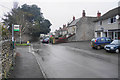
Direction Sign - Signpost on High Street in Wookey
Pyramid finial - 4 arms; Somerset SCC pyramid by the UC road, in parish of Wookey (Mendip District), on the northeast side of the crossroads of High Street, Henley Lane, Doctor's Hill and Vicarage Road.
surveyed
Milestone Society National ID: SO_ST5145C
Image: © Milestone Society
Taken: 2 Feb 2013
0.12 miles
2
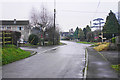
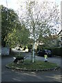
Crossroads in Wookey
I was expecting more of a sense of a village centre, but this is just sleepy and residential.
Image: © Bill Boaden
Taken: 30 Dec 2016
0.13 miles
3
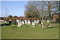
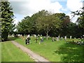
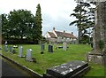
Greenfields Parish of Wookey
Cemetery on Doctor's Hill
Image: © Adrian and Janet Quantock
Taken: 19 Mar 2006
0.14 miles
4
Bus stop in Wookey
Near the centre of the village. On the right is Wookey Hub, a village shop and cafe.
Image: © Bill Boaden
Taken: 30 Dec 2016
0.15 miles
5
Wookey Triangle
A tiny patch of green along the High Street in Wookey is home to a wheelbarrow display. It was part of a restoration project for the Millennium.
Image: © Neil Owen
Taken: 21 Oct 2021
0.15 miles
7

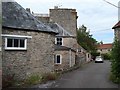
Church Cottage, Wookey
From St Matthew's churchyard.
Image: © Chris Brown
Taken: 9 Jul 2019
0.16 miles
8
High Street, Wookey
Seen from in front of the north lychgate to St Matthew's churchyard. The jumble of buildings in the foreground are outbuildings of the tall house beyond, Mellifont Abbey.
Image: © Chris Brown
Taken: 9 Jul 2019
0.16 miles
9
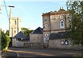
St Matthew's church and Mellifont Abbey, Wookey
The house known as Mellifont Abbey - the name taken from a Cistercian abbey near Drogheda in County Louth - was formerly the vicarage and is now a care home. Though an early 19th century Gothic folly, it includes earlier masonry thought to be taken from nearby Court Farm.
Image: © Chris Brown
Taken: 8 Jul 2019
0.17 miles