IMAGES TAKEN NEAR TO
Hornblotton, SHEPTON MALLET, BA4 6SF
Introduction
This page details the photographs taken nearby to BA4 6SF by members of the Geograph project.
The Geograph project started in 2005 with the aim of publishing, organising and preserving representative images for every square kilometre of Great Britain, Ireland and the Isle of Man.

There are currently over 7.5m images from over14,400 individuals and you can help contribute to the project by visiting https://www.geograph.org.uk
Image Map
Images are licensed for reuse under creativecommons.org/licenses/by-sa/2.0
Notes
- Clicking on the map will re-center to the selected point.
- The higher the marker number, the further away the image location is from the centre of the postcode.
Image Listing (8 Images Found)
Images are licensed for reuse under creativecommons.org/licenses/by-sa/2.0
Image
Details
Distance
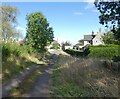
1
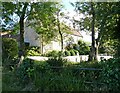
Hornblotton Green
Part of the rather scattered, with no obvious centre, Hornblotton.
Image: © Richard Webb
Taken: 7 Apr 2015
0.02 miles
2
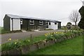
Hornblotton Village Hall
Very small, like Hornblotton.
Image: © Richard Webb
Taken: 7 Apr 2015
0.04 miles
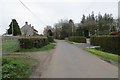
3

Entrance to Mendip Farm
A view looking to the southwest towards the entrance to Mendip Farm.
Image: © Phil Williams
Taken: 29 Sep 2007
0.04 miles
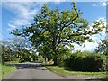
4
Hornblotton Green
Part of the scattered parish of Hornblotton.
Image: © Richard Webb
Taken: 7 Apr 2015
0.08 miles
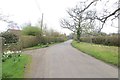
7
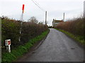
Lane and Gas pipeline marker
This is the lane between Hornblotton Green and Lovington just south of Hornblotton and north of Rectory Farm. The bright marker post shows the position of a gas pipeline clearly visible from the air.
Image: © Nigel Mykura
Taken: 29 Feb 2008
0.16 miles