IMAGES TAKEN NEAR TO
Leg Square, SHEPTON MALLET, BA4 5LQ
Introduction
This page details the photographs taken nearby to Leg Square, BA4 5LQ by members of the Geograph project.
The Geograph project started in 2005 with the aim of publishing, organising and preserving representative images for every square kilometre of Great Britain, Ireland and the Isle of Man.

There are currently over 7.5m images from over14,400 individuals and you can help contribute to the project by visiting https://www.geograph.org.uk
Image Map
Images are licensed for reuse under creativecommons.org/licenses/by-sa/2.0
Notes
- Clicking on the map will re-center to the selected point.
- The higher the marker number, the further away the image location is from the centre of the postcode.
Image Listing (232 Images Found)
Images are licensed for reuse under creativecommons.org/licenses/by-sa/2.0
Image
Details
Distance
1
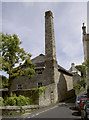
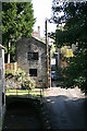
A tall chimney
Located at the junction of Leg Square and Cornhill, not far from the prison, this was a former mill served by a watercourse.
Image: © Neil Owen
Taken: 30 Jul 2012
0.01 miles
2
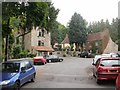
The Dusthole, Shepton Mallet
Located on the north side of Garston Street, adjacent to Leg Square.
Also known as The Kings Arms, this a modernised former coaching inn dating back several centuries. The accommodation is 10 en-suite bedrooms.
Image: © Jaggery
Taken: 7 Jul 2010
0.01 miles
3
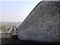
The high wall of HMP Shepton Mallet
The forbidding stone wall of HMP Shepton Mallett, one of the oldest prisons. In the war, it was handed over to the US forces and executions of black soldiers took place there, who had been found guilty of desertion. It is said that bullet holes can still be found in the walls inside the prison.
Image: © Tom Jolliffe
Taken: 26 Mar 2007
0.02 miles
4
Shepton Mallet: Leg Square
With the chimney of Town Mill on the left. The building seen through the gap to the right of the lamp post is a wing of Shepton Mallet gaol, built in 1817-1822
Image: © Martin Bodman
Taken: 21 Sep 2008
0.02 miles
5
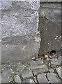
Benchmark in Peter Street
A cutmark, as described in the Benchmark Database: http://www.bench-marks.org.uk/bm45320 , on the footings of a house in Peter Street. See Image] for a wider view.
Image: © Neil Owen
Taken: 30 Jul 2012
0.03 miles
6
Looking up Peter Street
Up from the crossroads, Peter Street leads to the church of St Peter and St Paul. A benchmark has been made on the stonework of the large wall - see Image
Image: © Neil Owen
Taken: 30 Jul 2012
0.03 miles
7
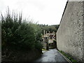
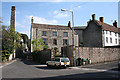
Gaol Lane, Shepton Mallett
The perimeter wall of the gaol on the right.
Image: © Jonathan Thacker
Taken: 23 Sep 2021
0.03 miles
8
Shepton Mallet: Lower Lane
Seen from Edengrove footbridge, looking towards Leg Square. The footpath signposted over the river Sheppey leads to Barren Down and the Fosse Way
Image: © Martin Bodman
Taken: 21 Sep 2008
0.04 miles
9
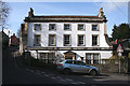
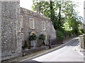
Shepton Mallet: No 1, Leg Square
This house, once known as ‘Eden Grove’ was built circa 1750 and is now listed Grade II. A Georgian house, built for a clothier or woollen merchant
Image: © Martin Bodman
Taken: 2 Mar 2009
0.04 miles
10
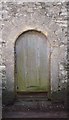
Old Arched Doorway opposite HMP Shepton Mallet
The door itself is affected by green mould/algae, perhaps adding to its charm
Image: © Tom Jolliffe
Taken: 26 Mar 2007
0.04 miles