IMAGES TAKEN NEAR TO
The Mead, Draycott Road, SHEPTON MALLET, BA4 5HY
Introduction
This page details the photographs taken nearby to The Mead, Draycott Road, BA4 5HY by members of the Geograph project.
The Geograph project started in 2005 with the aim of publishing, organising and preserving representative images for every square kilometre of Great Britain, Ireland and the Isle of Man.

There are currently over 7.5m images from over14,400 individuals and you can help contribute to the project by visiting https://www.geograph.org.uk
Image Map
Images are licensed for reuse under creativecommons.org/licenses/by-sa/2.0
Notes
- Clicking on the map will re-center to the selected point.
- The higher the marker number, the further away the image location is from the centre of the postcode.
Image Listing (257 Images Found)
Images are licensed for reuse under creativecommons.org/licenses/by-sa/2.0
Image
Details
Distance
1
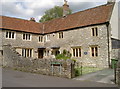
Longbridge Cottage
This charming stone cottage, part of the more extensive Longbridge House, is open for paying guests. But once the ill-fated James, Duke of Monmouth stayed at the house before his defeat at the Battle of Sedgemoor in July, 1685. The cottage is Grade II listed.
Image: © Neil Owen
Taken: 21 May 2014
0.02 miles
2
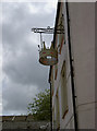
A lofty crown
Sign outside the Crown Inn, Cat's Ash. See Image] for a wider view of this pink pub.
Image: © Neil Owen
Taken: 21 May 2014
0.02 miles
3
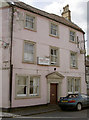
The Crown Inn
A somewhat run-down looking pub. It has been through some difficult times and looks in need of a boost. See Image] for the sign.
Image: © Neil Owen
Taken: 21 May 2014
0.02 miles
4

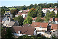
Shepton Mallet: towards Cowl Street
A view over the Sheppey valley. Beyond lower Shepton can be seen a surviving viaduct of the Somerset & Dorset Joint Railway: the line climbed up to a summit at Maesbury, on Mendip
Image: © Martin Bodman
Taken: 21 Sep 2008
0.03 miles
5

Only one hoop to aim at
The small and narrow spit of land at the divergence of Draycott Road is home to a single basketball hoop. The road where this was taken from only came into being during the 1960s, whereas the road to the left around the court is much older. Previously this area boasted silk and brush factories, as well as the historic priory, convent and Sale's House, some of which remain in the background.
Image: © Neil Owen
Taken: 21 May 2014
0.03 miles
6

Looking north-northeast from Hill Lane
This is a path that runs above Cat’s Ash and affords good views over the town.
Image: © John Baker
Taken: 4 Apr 2016
0.04 miles
7
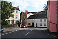
Shepton Mallet: towards Draycott Road
With the roof of Sales House just visible on the left. Beyond it, to the right, stand the low-rise apartment blocks built in the 1960s and 1970s when this part of lower Shepton was re-developed
Image: © Martin Bodman
Taken: 21 Sep 2008
0.04 miles
8
Shepton Mallet: towards Tipcote Hill
A meeting of streets: the turning on the left is Lower Lane, which leads to Leg Square. Tipcote Hill is the turning beyond the red car. The main road runs round to the right to become Catsash, passing the pink-washed Crown, now or recently a public house
Image: © Martin Bodman
Taken: 21 Sep 2008
0.04 miles
9

Shepton Mallet: Draycott Road
This part of Shepton Mallet was substantially re-developed in the 1960s and 1970s. Steam and water-powered mills such as Draycott, Eiffel House and Longbridge factory were swept away and a housing estate erected, consisting mainly of low-rise apartment blocks
Image: © Martin Bodman
Taken: 21 Sep 2008
0.04 miles
10

Shepton Mallet: Sales House
In Draycott Road. A Georgian house with two wings, one attached, which reputedly served as premises in the silk industry before being pressed into use as a nunnery in the early 19th century
Image: © Martin Bodman
Taken: 21 Sep 2008
0.04 miles