IMAGES TAKEN NEAR TO
Back Lane, SHEPTON MALLET, BA4 5HF
Introduction
This page details the photographs taken nearby to Back Lane, BA4 5HF by members of the Geograph project.
The Geograph project started in 2005 with the aim of publishing, organising and preserving representative images for every square kilometre of Great Britain, Ireland and the Isle of Man.

There are currently over 7.5m images from over14,400 individuals and you can help contribute to the project by visiting https://www.geograph.org.uk
Image Map
Images are licensed for reuse under creativecommons.org/licenses/by-sa/2.0
Notes
- Clicking on the map will re-center to the selected point.
- The higher the marker number, the further away the image location is from the centre of the postcode.
Image Listing (15 Images Found)
Images are licensed for reuse under creativecommons.org/licenses/by-sa/2.0
Image
Details
Distance
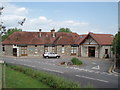
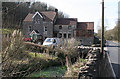
1
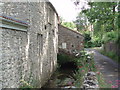
Darshill silk mills
The buildings on the left are relatively modern constructions, whilst the building in the rear of the photograph is one of the original silk mill buildings. The silk mills have now been converted into flats and houses.
Image: © Sharon Loxton
Taken: 25 Jun 2006
0.02 miles
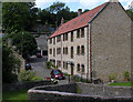
2
Shepton Mallet: housing at Darshill
On the site of Darshill Middle Mill, a water-powered woollen mill, later functioning as a silk mill in the 19th century. The much latrger Higher and Lower Mills - factories- at Darshill have both gone: the Lower Mill was gutted by fire in the 19th century and Shepton's sewage works now utilises the site. The Higher Mill survived into the 20th century, but has since been replaced by more housing
Image: © Martin Bodman
Taken: 21 Sep 2008
0.02 miles
3
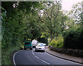
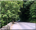
2011 : A371 passing Darshill heading west
About four miles from Wells.
Image: © Maurice Pullin
Taken: 11 Jun 2011
0.04 miles
4
Darshill and the river Sheppey
The river Sheppey emerging from what was once a silk mill. The Darshill area, on the Wells road just to the west of Shepton Mallet, had many silk mills all powered by the river Sheppey.
Image: © Sharon Loxton
Taken: 25 Jun 2006
0.05 miles
5
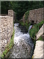
River Sheppey
The river Sheppey tumbling down man made steps on its way towards Darshill and the silk mills which once flourished there.
Image: © Sharon Loxton
Taken: 25 Jun 2006
0.05 miles
6
2011 : Darshill, west of Shepton Mallet
Not sure if this is an old mill converted to residential use or a genuine new build. The walls look modern but it could be cladding on an old surface. Suspect the former, there was a silk mill on this site.
Seen from the A371.
Image: © Maurice Pullin
Taken: 11 Jun 2011
0.06 miles
7
2011 : A371 about to enter Shepton Mallet
After Shepton Mallet the A371 turns south to Castle Cary.
Image: © Maurice Pullin
Taken: 11 Jun 2011
0.09 miles
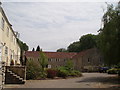
8

Shepton Mallet: Sheppey at Darshill
The A371 Shepton-Wells road runs beside the river Sheppey and was opened to traffic in 1851. Photo taken near the site of Upper Darshill Mill, now occupied by a housing block
Image: © Martin Bodman
Taken: 8 Nov 2008
0.15 miles
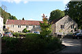
9
Shepton Mallet: Darshill House
A watermill, now converted and known as Silkmill Barn, is out of shot to the left. It was previously Middle Mill, Darshill. In this shot, to the right of Darshill House, by the Shepton-Wells road – constructed in 1851-1853 – is a ‘handle house’ with apertures in the brickwork, where teazles were dried. Teazles were used to raise the knap on woollen cloth, prior to shearing, in the days when Middle Mill was fulling cloth, prior to its conversion to a silk mill in the 19th century. The river Sheppey runs in the foreground
Image: © Martin Bodman
Taken: 2 Mar 2009
0.15 miles