Shepton Mallet: Darshill House
Introduction
The photograph on this page of Shepton Mallet: Darshill House by Martin Bodman as part of the Geograph project.
The Geograph project started in 2005 with the aim of publishing, organising and preserving representative images for every square kilometre of Great Britain, Ireland and the Isle of Man.

There are currently over 7.5m images from over 14,400 individuals and you can help contribute to the project by visiting https://www.geograph.org.uk
Shepton Mallet: Darshill House
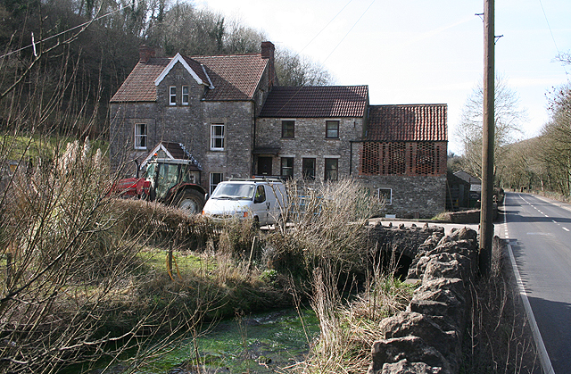
Image: © Martin Bodman Taken: 2 Mar 2009
A watermill, now converted and known as Silkmill Barn, is out of shot to the left. It was previously Middle Mill, Darshill. In this shot, to the right of Darshill House, by the Shepton-Wells road – constructed in 1851-1853 – is a ‘handle house’ with apertures in the brickwork, where teazles were dried. Teazles were used to raise the knap on woollen cloth, prior to shearing, in the days when Middle Mill was fulling cloth, prior to its conversion to a silk mill in the 19th century. The river Sheppey runs in the foreground
Images are licensed for reuse under creativecommons.org/licenses/by-sa/2.0
Image Location
Latitude
51.192939
Longitude
-2.56821