IMAGES TAKEN NEAR TO
Westholme, SHEPTON MALLET, BA4 4EW
Introduction
This page details the photographs taken nearby to Westholme, BA4 4EW by members of the Geograph project.
The Geograph project started in 2005 with the aim of publishing, organising and preserving representative images for every square kilometre of Great Britain, Ireland and the Isle of Man.

There are currently over 7.5m images from over14,400 individuals and you can help contribute to the project by visiting https://www.geograph.org.uk
Image Map
Images are licensed for reuse under creativecommons.org/licenses/by-sa/2.0
Notes
- Clicking on the map will re-center to the selected point.
- The higher the marker number, the further away the image location is from the centre of the postcode.
Image Listing (8 Images Found)
Images are licensed for reuse under creativecommons.org/licenses/by-sa/2.0
Image
Details
Distance
1
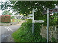
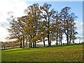
Crossroads near Pilton
One of the smartest road signs in the area !
Image: © Nigel Freeman
Taken: 2 Aug 2005
0.09 miles
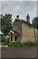
4
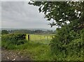
Old Direction Sign - Signpost by Upper Westholme crossroads, Pilton Parish
Pyramid finial - 4 arms; Somerset pointing fingers by the UC road, in parish of Pilton (Mendip District), Upper Westholme crossroads.
Surveyed
Milestone Society National ID: SO_ST5841
Image: © Milestone Society
Taken: Unknown
0.15 miles
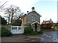
5
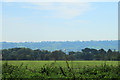
2011 : South from Folly Lane
On Stoodly Hill.
Perridge Hill and Upper Westholme lost in the woods on the other side of the field are in the same grid square. Pennard Hill in the distance is also shrouded this time in a heat haze.
Image: © Maurice Pullin
Taken: 1 Oct 2011
0.17 miles
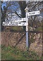
8
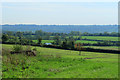
2011 : South east from Stoodly Lane
A field of drying grass is almost ready to be gathered in, probably for silage this time of year. A couple of fields over Higher Westholm Road can be seen between it's hedegerows, still in the same grid square.
Pennard Hill in the distance is partly masked by the heat haze - heat haze you say, on the 1st of October? Yes it really was, brought about by a weekend of temperatures in the high 20's.
Image: © Maurice Pullin
Taken: 1 Oct 2011
0.22 miles