IMAGES TAKEN NEAR TO
The Green, RADSTOCK, BA3 5UY
Introduction
This page details the photographs taken nearby to The Green, BA3 5UY by members of the Geograph project.
The Geograph project started in 2005 with the aim of publishing, organising and preserving representative images for every square kilometre of Great Britain, Ireland and the Isle of Man.

There are currently over 7.5m images from over14,400 individuals and you can help contribute to the project by visiting https://www.geograph.org.uk
Image Map
Images are licensed for reuse under creativecommons.org/licenses/by-sa/2.0
Notes
- Clicking on the map will re-center to the selected point.
- The higher the marker number, the further away the image location is from the centre of the postcode.
Image Listing (25 Images Found)
Images are licensed for reuse under creativecommons.org/licenses/by-sa/2.0
Image
Details
Distance
1
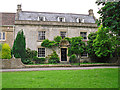
Green Farm House
Facing on to the village green at Faulkland, probably built in the late 18th century.
A listed building - for architectural details see http://www.imagesofengland.org.uk/details/default.aspx?id=267896 .
Image: © Rose and Trev Clough
Taken: 23 Jun 2016
0.01 miles
2
Village green, Faulkland
The village stocks made between 16th/17th century stand between two roughly hewn standing stones. There are several other standing stones around the village.
Image: © Maigheach-gheal
Taken: 19 Apr 2009
0.02 miles
3
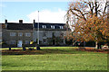
Hemington: Faulkland
Looking west-north-west to houses on the green at Faulkland. Seen from the A366 road
Image: © Martin Bodman
Taken: 23 Nov 2006
0.02 miles
4
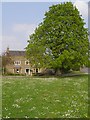
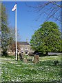
Horse chestnut tree on the green, Faulkland
In the foreground is the village green at Faulkland, covered in daisies. The A366 road is to the right of the large horse chestnut tree.
Image: © Jim Champion
Taken: 15 Apr 2007
0.02 miles
5
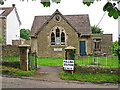
Faulkland Village Hall on EU referendum day
Originally a village school, dating from the 19th century - see Historic Environment record http://webapp1.somerset.gov.uk/her/details.asp?prn=28011 .
The building was gifted to the parish council in 1953 - see Image .
Image: © Rose and Trev Clough
Taken: 23 Jun 2016
0.03 miles
6
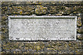
Commemorative plaque, Faulkland Village Hall
For location see Image .
Ownership of the hall was conveyed to the parish council in commemoration of the coronation of Queen Elizabeth II in 1953.
Image: © Rose and Trev Clough
Taken: 23 Jun 2016
0.03 miles
7
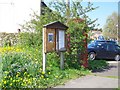
Notice board, Faulkland
The village notice board and the K6 style telephone box is beside the village green.
Image: © Maigheach-gheal
Taken: 19 Apr 2009
0.04 miles
8
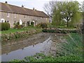
Village pond and cottages, Faulkland
This pond is to the south of the A366 road through Faulkland, near Bishop Street. The parish newsletter of October 2006 reports that the parish council is seeking to establish whether it has ownership of the pond, with a view to cleaning it out. It looks like it has been cleaned out.
Image: © Jim Champion
Taken: 15 Apr 2007
0.05 miles
9
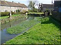
Village pond, Faulkland
The village pond is known as the Horsepond in history books.
Image: © Maigheach-gheal
Taken: 19 Apr 2009
0.05 miles
10
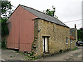
An old stone garage or workshop
Image: © Rose and Trev Clough
Taken: 23 Jun 2016
0.06 miles