IMAGES TAKEN NEAR TO
Charlton, RADSTOCK, BA3 5TL
Introduction
This page details the photographs taken nearby to Charlton, BA3 5TL by members of the Geograph project.
The Geograph project started in 2005 with the aim of publishing, organising and preserving representative images for every square kilometre of Great Britain, Ireland and the Isle of Man.

There are currently over 7.5m images from over14,400 individuals and you can help contribute to the project by visiting https://www.geograph.org.uk
Image Map
Images are licensed for reuse under creativecommons.org/licenses/by-sa/2.0
Notes
- Clicking on the map will re-center to the selected point.
- The higher the marker number, the further away the image location is from the centre of the postcode.
Image Listing (10 Images Found)
Images are licensed for reuse under creativecommons.org/licenses/by-sa/2.0
Image
Details
Distance
1
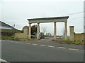
Entrance arch to Charlton Park estate
The entrance arch at Charlton park estate has been re-erected after demolition some years ago. Pic taken in December 2016 before ironwork had been re-installed and side walls re-built.
Image: © Phil Williams
Taken: 19 Dec 2016
0.01 miles
2

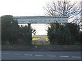
Ornate Gateway at Charlton
The lodge house and gateway into Charlton Park near Radstock.
Image: © Dr Duncan Pepper
Taken: 7 Mar 2008
0.02 miles
3
Charlton Park
A view looking west across the B3139 to the ornate arch at the entrance to Charlton Park estate.
Image: © Phil Williams
Taken: 25 Feb 2006
0.07 miles
4
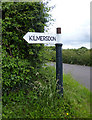
Old Direction Sign - Signpost near the B3139, Kilmersdon parish
Lost finial - 1 arm; Somerset SCC pyramid (Sheldon) by the B3139, in parish of Kilmersdon (Mendip District), East of Charlton Lodge, North of Y-junction with Kilmersdon Road, at T-junction.
Surveyed
Milestone Society National ID: SO_ST6852A
Image: © Alan Rosevear
Taken: 24 Jun 2013
0.07 miles
5
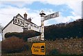
Old Direction Sign - Signpost by the B3139, Charlton Cottage, Kilmersdon parish
Pyramid finial - 3 arms; Somerset SCC pyramid by the B3139, in parish of Kilmersdon (Mendip District), Charlton Road junction Southeast of Charlton.
Surveyed
Milestone Society National ID: SO_ST6852
Image: © Milestone Society
Taken: Unknown
0.13 miles
6
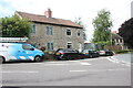
House near Charlton
This house sits right on the junction where the minor road the B3139 from Charlton meets the minor road from Kilmersdon to Holcombe.
Image: © Nigel Mykura
Taken: 23 Jul 2023
0.14 miles
7
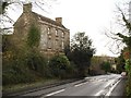
B3139 in Charlton
The impressively symmetrical front of the C18 Prospect House http://www.imagesofengland.org.uk/Details/Default.aspx?id=267937&mode=adv overlooks the road as it drops down towards Snail's Bottom.
Image: © Derek Harper
Taken: 26 Nov 2009
0.17 miles
8
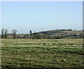
2008 : West near Charlton
From a convenient layby on the road south to Holcombe.
The hill slopes down to Kilmersdon to the left.
Image: © Maurice Pullin
Taken: 25 Nov 2008
0.18 miles
9
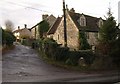
Charlton
Most of the small village of Charlton lies on this side turning off the B3139 (foreground). The C17 houses on the left and the right are both listed http://www.imagesofengland.org.uk/details/default.aspx?id=267935 http://www.imagesofengland.org.uk/Details/Default.aspx?id=267936&mode=adv .
Image: © Derek Harper
Taken: 26 Nov 2009
0.20 miles
10
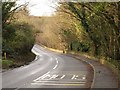
B3139 near Charlton
The main road through Charlton crosses Snail's Bottom, a little down the hill from the scene in Image The opening on the right is for footpath FR 7/11 down the valley to Radstock.
Image: © Derek Harper
Taken: 26 Nov 2009
0.23 miles