IMAGES TAKEN NEAR TO
Beacon View, RADSTOCK, BA3 5PE
Introduction
This page details the photographs taken nearby to Beacon View, BA3 5PE by members of the Geograph project.
The Geograph project started in 2005 with the aim of publishing, organising and preserving representative images for every square kilometre of Great Britain, Ireland and the Isle of Man.

There are currently over 7.5m images from over14,400 individuals and you can help contribute to the project by visiting https://www.geograph.org.uk
Image Map (Loading...)


Getting Data...Please wait
Leaflet Map data © OpenStreetMap
Images are licensed for reuse under creativecommons.org/licenses/by-sa/2.0
Notes
- Clicking on the map will re-center to the selected point.
- The higher the marker number, the further away the image location is from the centre of the postcode.
Image Listing (31 Images Found)
Images are licensed for reuse under creativecommons.org/licenses/by-sa/2.0
Image
Details
Distance
1
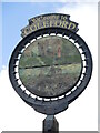
Welcome to Coleford
A hand-painted village sign; pity the elements have taken the shine off it as it looks rather fetching. See Image] for a wider view of the roadside position.
Image: © Neil Owen
Taken: 4 Aug 2021
0.09 miles
2

A village that remembers
Coleford's village signpost also provides room for a silhouette of a soldier. See Image] for a better look at the hanpainted sign. The bench seat beyond marks the Queen's Diamond Jubilee, 2012.
Image: © Neil Owen
Taken: 4 Aug 2021
0.09 miles
3
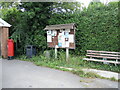
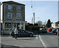
A post box remains
The village post office was here up until quite recently, but the premises are now a piano shop. However, the postbox and a notice board remain on site.
Image: © Neil Owen
Taken: 4 Aug 2021
0.10 miles
4
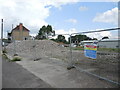
The Crossways garage is crushed
No more petrol at this station. Having been declared redundant it has been demolished to make room for a new store and a house.
Image: © Neil Owen
Taken: 4 Aug 2021
0.11 miles
5
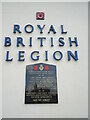
The Legion scroll
Coleford Royal British Legion hall has this stone plaque on the front that records the fallen of both world wars. It seems such an obvious place to have a war memorial, yet not many do. See Image] for a location view.
Image: © Neil Owen
Taken: 4 Aug 2021
0.11 miles
6
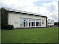
Coleford Royal British Legion hall
The hall was built in 1956, with later extensions. See Image] for a look at the front sign and legend.
Image: © Neil Owen
Taken: 4 Aug 2021
0.11 miles
7
2009 : Cross Ways Fish Bar, Highbury
Or should that be Coleford?
It isn't really a cross ways either, more of a T junction. At least one inhabitant seem a little puzzled. If the fish and chips taste as good as they smelled, who cares?
Image: © Maurice Pullin
Taken: 22 Mar 2009
0.12 miles
8
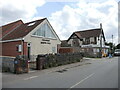
Coleford Gospel Hall
The village had held some meetings in various places before a worshipper, Harry Beer, drove a horse and cart to Devizes to purchase an old army hut. The corrugated hut became the first hall for the community by 1920. Later meetings were also held under canvas as the needs outgrew. Today this spacious modern hall welcomes all.
Image: © Neil Owen
Taken: 4 Aug 2021
0.12 miles
9
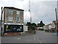
Coleford pharmacy
At the top of Church Street. Prior to this it was the village fish and chip shop.
Image: © Neil Owen
Taken: 4 Aug 2021
0.12 miles
10
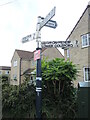
Coleford and Highbury signpost
At the junction of Anchor Road and Church Street. Coleford is nowhere near the sea but presumably Anchor Road is named after the Anchor Inn further up the way.
Image: © Neil Owen
Taken: 4 Aug 2021
0.13 miles