IMAGES TAKEN NEAR TO
Midway, RADSTOCK, BA3 5JE
Introduction
This page details the photographs taken nearby to Midway, BA3 5JE by members of the Geograph project.
The Geograph project started in 2005 with the aim of publishing, organising and preserving representative images for every square kilometre of Great Britain, Ireland and the Isle of Man.

There are currently over 7.5m images from over14,400 individuals and you can help contribute to the project by visiting https://www.geograph.org.uk
Image Map
Images are licensed for reuse under creativecommons.org/licenses/by-sa/2.0
Notes
- Clicking on the map will re-center to the selected point.
- The higher the marker number, the further away the image location is from the centre of the postcode.
Image Listing (6 Images Found)
Images are licensed for reuse under creativecommons.org/licenses/by-sa/2.0
Image
Details
Distance
1
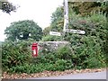
Signpost near Stoke St Michael
The junction is at the corner of minor roads from Three Ashes. The signpost is a little on the wonky side, but it still indicates the way to go. The postbox is Elizabeth II reign.
Image: © Maigheach-gheal
Taken: 18 Sep 2009
0.18 miles
2
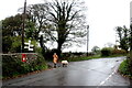
Wet Saturday Dog Walking near Withybrook
The dog walker passing the box-in-the-wall post box is turning off the Fosse Road into the minor road that runs down to Stoke Bottom. The Fosse Rd carries on to Stoke St Michael. The road she is heading down is signposted to Nettlebridge.
Image: © Nigel Mykura
Taken: 5 Nov 2022
0.19 miles
3
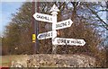
Old Direction Sign - Signpost by Fosse Road, Withybrook, Stoke St Michael Parish
Pyramid finial - 4 arms; Somerset SCC pyramid by the UC road, in parish of Stoke St Michael (Mendip District), Fosse Road, junction with Kiln Lane, Withybrook.
Surveyed
Milestone Society National ID: SO_ST6547
Image: © Milestone Society
Taken: Unknown
0.19 miles
4
Footpath to Withybrook
A view looking to the northeast along the course of the public footpath from Three Ashes to Withybrook.
Image: © Phil Williams
Taken: 15 Jun 2007
0.22 miles
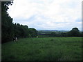
5
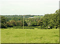
2009 : North from Three Ashes
Mostly pasture land.
The distant ridge is above Nettlebridge and Benter.
Image: © Maurice Pullin
Taken: 11 Sep 2009
0.23 miles
6
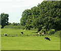
2009 : Cattle grazing in a field near Withybrook
Safe in the ignorance of what lies beneath them. See previous images in this square.
Image: © Maurice Pullin
Taken: 11 Sep 2009
0.24 miles