IMAGES TAKEN NEAR TO
Grange End, RADSTOCK, BA3 4XA
Introduction
This page details the photographs taken nearby to Grange End, BA3 4XA by members of the Geograph project.
The Geograph project started in 2005 with the aim of publishing, organising and preserving representative images for every square kilometre of Great Britain, Ireland and the Isle of Man.

There are currently over 7.5m images from over14,400 individuals and you can help contribute to the project by visiting https://www.geograph.org.uk
Image Map
Images are licensed for reuse under creativecommons.org/licenses/by-sa/2.0
Notes
- Clicking on the map will re-center to the selected point.
- The higher the marker number, the further away the image location is from the centre of the postcode.
Image Listing (3 Images Found)
Images are licensed for reuse under creativecommons.org/licenses/by-sa/2.0
Image
Details
Distance
1
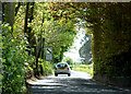
2010 : B3355 Silver Street leaving Midsomer Norton
Heading south to join the A367 one mile ahead.
The notice under the delimiting sign says "Thank you for driving carefully through our town". How do they know?
Image: © Maurice Pullin
Taken: 10 May 2010
0.18 miles
2
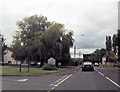
Entering Midsomer Norton from Charlton Park
Image: © John Firth
Taken: 4 Sep 2017
0.23 miles
3
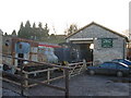
Railway Centre at Midsomer Norton
A view looking west to the engine shed at the railway centre at the old Somerset and Dorset Joint Railway station at Midsomer Norton. An old WWII pillbox can be seen on the hill to the left of the shed roof.
Image: © Phil Williams
Taken: 21 Jan 2006
0.24 miles