IMAGES TAKEN NEAR TO
Emborough, RADSTOCK, BA3 4SA
Introduction
This page details the photographs taken nearby to BA3 4SA by members of the Geograph project.
The Geograph project started in 2005 with the aim of publishing, organising and preserving representative images for every square kilometre of Great Britain, Ireland and the Isle of Man.

There are currently over 7.5m images from over14,400 individuals and you can help contribute to the project by visiting https://www.geograph.org.uk
Image Map (Loading...)


Getting Data...Please wait
Leaflet Map data © OpenStreetMap
Images are licensed for reuse under creativecommons.org/licenses/by-sa/2.0
Notes
- Clicking on the map will re-center to the selected point.
- The higher the marker number, the further away the image location is from the centre of the postcode.
Image Listing (10 Images Found)
Images are licensed for reuse under creativecommons.org/licenses/by-sa/2.0
Image
Details
Distance
1

Old Down Inn, Emborough Crossroads
Since the old map was produced the A37 and B3139 have been realigned. The old B road survives as part of this pub's extended car park.
Image: © ChurchCrawler
Taken: 16 Mar 2006
0.11 miles

3

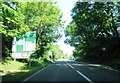
A37 nears Old Down junction with the B3139
Image: © Colin Pyle
Taken: 22 Apr 2018
0.15 miles
5
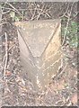
Old Milepost by the A37, south of railway bridge, Binegar parish
Cast iron post by the A37, in parish of BINEGAR (MENDIP District), just South of old railway bridge between Old Down and Gurney Slade, beside road on bank, on East side of road. Plated iron casting, erected by the Shepton Mallet turnpike trust in the 19th century.
Inscription reads:-
: SHEPTON / MALLET / 5 : : GLOSTER / 50 : : BRISTOL / 15 :
Somerset HER.
HER number: 19340 https://www.heritagegateway.org.uk/Gateway/Results_Single.aspx?uid=19340&resourceID=100
Milestone Society National ID: SO_SMBR05.
Image: © JR Dowding
Taken: 25 Dec 2002
0.16 miles
6
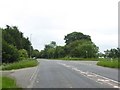
Staggered crossroads with A37 at Old Down
The staggered crossroads is the result of a major realignment of the roads. Formerly the B3139, crossing the A37 here, was straight, and the A37 met the minor road in a staggered crossroads (turn left, then right). The former route can be followed in the hedges, with a house built where the A37 formerly ran south of the crossroads
Image: © David Smith
Taken: 10 Jun 2017
0.16 miles
7
Bridge 59, Somerset & Dorset Railway / A37
The abutments of the former railway bridge over the A37 still survive just south of Emborough crossroads.
Image: © ChurchCrawler
Taken: 16 Mar 2006
0.19 miles
8
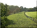
2009 : Somerset & Dorset Joint Railway (dismantled)
Now you railway lovers, prepare to shed a tear for all that remains of the Slow and Dirty as it was affectionately called.
Running from Bath Green Park it went south through Midford, Wellow, Radstock, Midsomer Norton, such wonderful names, passing here before continuing to Shepton Mallet eventually arriving at Weymouth.
Rails and trackbed have long gone from this short stretch but it remains fenced off to allay its spirit.
Image: © Maurice Pullin
Taken: 10 Oct 2009
0.19 miles
9
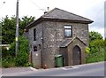
Old Toll House, Old Down
Toll House by the B3139, The Old Turnpike, Old Down, Lynch Hill at its junction with Coalpit Lane, Chilcompton.
Somerset HER.
HER number: 36823. https://www.heritagegateway.org.uk/Gateway/Results_Single.aspx?uid=36823&resourceID=100
Surveyed
Milestone Society National ID: SO.CHC
Image: © Alan Rosevear
Taken: 24 Jun 2013
0.21 miles
10
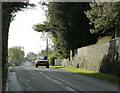
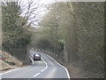
2009 : B3139 nearly at Old Down
Taken at the end of Thickthorn Lane. Chilcompton has been left behind, Old Down approaches and the A37 is soon to be crossed.
Image: © Maurice Pullin
Taken: 10 Oct 2009
0.24 miles