IMAGES TAKEN NEAR TO
Stratton-on-the-Fosse, RADSTOCK, BA3 4RL
Introduction
This page details the photographs taken nearby to BA3 4RL by members of the Geograph project.
The Geograph project started in 2005 with the aim of publishing, organising and preserving representative images for every square kilometre of Great Britain, Ireland and the Isle of Man.

There are currently over 7.5m images from over14,400 individuals and you can help contribute to the project by visiting https://www.geograph.org.uk
Image Map
Images are licensed for reuse under creativecommons.org/licenses/by-sa/2.0
Notes
- Clicking on the map will re-center to the selected point.
- The higher the marker number, the further away the image location is from the centre of the postcode.
Image Listing (10 Images Found)
Images are licensed for reuse under creativecommons.org/licenses/by-sa/2.0
Image
Details
Distance
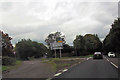
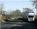
2
Turning for Chilcompton from the A367
Image: © Sarah Charlesworth
Taken: 16 Jun 2011
0.05 miles
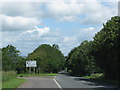
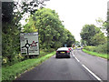
3
2008 : Looking north on the Fosse Way, A367
[The Fosse Way] runs from Exeter in the south west to Lincoln in the north-east, and was built in the middle of the 1st century AD. The word Fosse comes from the Latin word for ditch (Fossa) and is appropriate for this road as for a long time, the western boundary of Roman controlled Britain was protected by a defensive ditch running between Exeter and Lincoln. Whether the ditch was filled in and the road built later, or whether the road was built to follow the ditch is a subject of much conjecture. What is certain is that the road got its name from the ditch.
The above copied from http://www.rural-roads.co.uk/fosse/fosse1.shtml an interesting website.
Image: © Maurice Pullin
Taken: 25 Nov 2008
0.08 miles
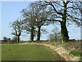
4
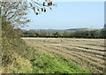
2008 : Looking east from Wells Road, B3139
A cropped field waiting for the plough. Probably a wheat field. Fields are rarely left fallow now, a crop such as oil seed rape or sometimes broad beans is sown which will improve the condition of the soil and still be productive.
Image: © Maurice Pullin
Taken: 25 Nov 2008
0.09 miles
5
2008 : Layby on the B3139 Wells Road
Charlton and Kilmersdon to the east in this direction, Chilcompton and Wells to the west.
Image: © Maurice Pullin
Taken: 25 Nov 2008
0.15 miles
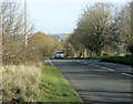
6

2009 : B3139 Wells Road
South of Radstock heading east. Joins the A367 half a mile further on.
Image: © Maurice Pullin
Taken: 22 Mar 2009
0.17 miles
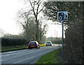
8
2008 : Field near Killings Knap Farm
From the A367.
It is interesting that Killings Knap Farm has no apostrophe whereas the nearby hamlet of Killing's Knap does.
Image: © Maurice Pullin
Taken: 25 Nov 2008
0.23 miles
9
2009 : B3139 heading south west
To Wells via West Horrington.
Image: © Maurice Pullin
Taken: 22 Mar 2009
0.23 miles
10
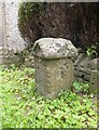
Possible Old Milestone by the B3139, Wells Road, Stratton on the Fosse
The stone is located by Norton Down Cottages, on the verge against the garden wall, on the south side of road. Parish of Stratton on the Fosse (Mendip District).
Initially the stone was considered to be a first generation milestone erected by the Wells turnpike trust in the 18th century. However, there is no evidence to support this. Any information about the stone would be appreciated.
Milestone Society National ID (Provisional): SO_BAWL11A
Image: © A Rosevear
Taken: 24 Jun 2013
0.25 miles