IMAGES TAKEN NEAR TO
Church Lane, RADSTOCK, BA3 4QS
Introduction
This page details the photographs taken nearby to Church Lane, BA3 4QS by members of the Geograph project.
The Geograph project started in 2005 with the aim of publishing, organising and preserving representative images for every square kilometre of Great Britain, Ireland and the Isle of Man.

There are currently over 7.5m images from over14,400 individuals and you can help contribute to the project by visiting https://www.geograph.org.uk
Image Map
Images are licensed for reuse under creativecommons.org/licenses/by-sa/2.0
Notes
- Clicking on the map will re-center to the selected point.
- The higher the marker number, the further away the image location is from the centre of the postcode.
Image Listing (21 Images Found)
Images are licensed for reuse under creativecommons.org/licenses/by-sa/2.0
Image
Details
Distance
1
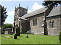
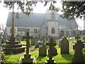
St. Vigor's church, Stratton-on-the-Fosse
An altogether humbler affair than Downside Abbey! Churchcrawler didn't get this one.
Image: © Jonathan Billinger
Taken: 5 Jun 2007
0.02 miles
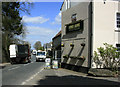
2
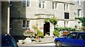
2010 : House for sale on Church Lane
The A367 passes along the far end of the road.
The tower at Downside Abbey stands like a friendly sentinel.
Image: © Maurice Pullin
Taken: 20 Apr 2010
0.04 miles
3
The church of St Vigor at Stratton-on-the-Fosse
One of only two churches named after St Vigor.
Image: © Peter Wood
Taken: 14 Mar 2013
0.05 miles
4
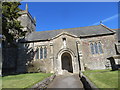
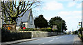
St Benedict's Church, Stratton-on-the Fosse
Nestling up close beside Downside Abbey, it's easily overlooked by its bigger neighbour.
Image: © Dr Duncan Pepper
Taken: 18 Mar 2009
0.05 miles
5
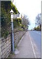
Old Direction Sign - Signpost by the A367, Fosse Way
Pyramid finial - 1 arm; Somerset SCC pyramid by the A367, in parish of Stratton-on-the-Fosse (Mendip District), opposite the junction with Church Lane.
Surveyed
Milestone Society National ID: SO_ST6550A
Image: © Milestone Society
Taken: Unknown
0.05 miles
6
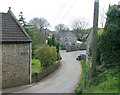
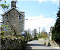
2010 : Church Lane, Stratton on the Fosse
Leaving the glamour of the A367 and Downside we are now in the backstreets of Stratton on the Fosse, giving access to places east.
Image: © Maurice Pullin
Taken: 20 Apr 2010
0.06 miles
7
2010 : A367 passing St.Olivers, Downside
Passing through Stratton-on-the-Fosse heading north toward Radstock.
"St Oliver’s House is the junior house of Downside School for boys and girls aged ten to thirteen."
From: http://www.downside.co.uk/School/boarding_day/st_olivers_house.html
Image: © Maurice Pullin
Taken: 20 Apr 2010
0.06 miles
8
2010 : Kings Arms, Stratton-on-the-Fosse
Situated on the A367.
Seen from the other side in Image]
I hear they do an excellent carvery.
Image: © Maurice Pullin
Taken: 20 Apr 2010
0.09 miles
9
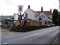
King's Arms, Stratton-on-the-Fosse
A local pub that does an excellent carvery.
Image: © Maigheach-gheal
Taken: 11 Jul 2009
0.09 miles