IMAGES TAKEN NEAR TO
Stratton-on-the-Fosse, RADSTOCK, BA3 4QF
Introduction
This page details the photographs taken nearby to BA3 4QF by members of the Geograph project.
The Geograph project started in 2005 with the aim of publishing, organising and preserving representative images for every square kilometre of Great Britain, Ireland and the Isle of Man.

There are currently over 7.5m images from over14,400 individuals and you can help contribute to the project by visiting https://www.geograph.org.uk
Image Map (Loading...)


Getting Data...Please wait
Leaflet Map data © OpenStreetMap
Images are licensed for reuse under creativecommons.org/licenses/by-sa/2.0
Notes
- Clicking on the map will re-center to the selected point.
- The higher the marker number, the further away the image location is from the centre of the postcode.
Image Listing (2 Images Found)
Images are licensed for reuse under creativecommons.org/licenses/by-sa/2.0
Image
Details
Distance
1
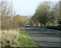
2008 : Looking north on the Fosse Way, A367
[The Fosse Way] runs from Exeter in the south west to Lincoln in the north-east, and was built in the middle of the 1st century AD. The word Fosse comes from the Latin word for ditch (Fossa) and is appropriate for this road as for a long time, the western boundary of Roman controlled Britain was protected by a defensive ditch running between Exeter and Lincoln. Whether the ditch was filled in and the road built later, or whether the road was built to follow the ditch is a subject of much conjecture. What is certain is that the road got its name from the ditch.
The above copied from http://www.rural-roads.co.uk/fosse/fosse1.shtml an interesting website.
Image: © Maurice Pullin
Taken: 25 Nov 2008
0.23 miles
2
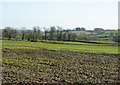
2008 : Field near Killings Knap
It looks most like a pasture but I doubt there is much grazing to be had.
Looking east from the Fosse Way A367 near Watery Lane.
Image: © Maurice Pullin
Taken: 25 Nov 2008
0.24 miles