IMAGES TAKEN NEAR TO
Litton, RADSTOCK, BA3 4PS
Introduction
This page details the photographs taken nearby to BA3 4PS by members of the Geograph project.
The Geograph project started in 2005 with the aim of publishing, organising and preserving representative images for every square kilometre of Great Britain, Ireland and the Isle of Man.

There are currently over 7.5m images from over14,400 individuals and you can help contribute to the project by visiting https://www.geograph.org.uk
Image Map (Loading...)


Getting Data...Please wait
Leaflet Map data © OpenStreetMap
Images are licensed for reuse under creativecommons.org/licenses/by-sa/2.0
Notes
- Clicking on the map will re-center to the selected point.
- The higher the marker number, the further away the image location is from the centre of the postcode.
Image Listing (22 Images Found)
Images are licensed for reuse under creativecommons.org/licenses/by-sa/2.0
Image
Details
Distance
1
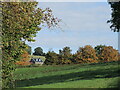
A farmhouse in the glade
Near to Litton reservoirs is Higher Shortwood Farm, nestling in the Chew valley.
Image: © Neil Owen
Taken: 11 Oct 2024
0.01 miles
2
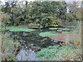
Litton Upper Reservoir
A bit overgrown now-but the swans seem to appreciate the peace & quiet
Image: © Dr Duncan Pepper
Taken: 23 Oct 2015
0.08 miles
3
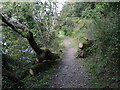
Reopening the path
A fallen tree has been partly cleared.
Image: © Neil Owen
Taken: 11 Oct 2024
0.10 miles
4
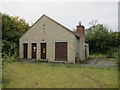
Litton sewage pumping station
I rather like the chimney, quite homely. The 55 Northing grid line appears to run across the middle of this building.
Image: © Dr Duncan Pepper
Taken: 23 Oct 2015
0.13 miles
5
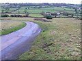
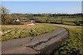
Hook Lane, north of Litton
Hook Lane drops down into the valley in which Litton is situated. This part of it is unfenced. The farm at the right is Elm Tree Farm at ST595552
Image: © Brian Robert Marshall
Taken: 17 Jan 2009
0.13 miles
6
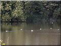
Mallard melodies
Litton reservoirs (particularly the Upper Reservoir) are a particularly quiet place and have an air of undisturbed nature about it. Plenty of ducks find it home by choice.
Image: © Neil Owen
Taken: 11 Oct 2024
0.13 miles
7
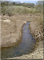
Barely a trickle
The River Chew flows down the hillside from the Mendips and is collected by the Litton (or Coley) reservoirs. However, today the levels are pretty low at the top end, exposing a lot of un-vegetated earth. See Image] for another view.
Image: © Neil Owen
Taken: 3 Apr 2013
0.14 miles
8
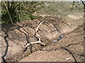
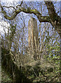
Fallen bough
Some of the organic and inorganic materials that collect in the reservoir are exposed at these low levels. See Image] for more views.
Image: © Neil Owen
Taken: 3 Apr 2013
0.15 miles
9
Fresh air
Part of Bristol Water Works reservoir at Litton includes a number of pipes and vent chimneys. This looks like one of the latter, although it's difficult to get much closer. See Image] for more views.
Image: © Neil Owen
Taken: 3 Apr 2013
0.15 miles
10
Hook Lane crossing Shortwood Common
Hook Lane descending across Shortwood Common with Shortwood Farm to the left.
Image: © Philip Halling
Taken: 15 Feb 2018
0.15 miles