IMAGES TAKEN NEAR TO
Lower Street, RADSTOCK, BA3 4GP
Introduction
This page details the photographs taken nearby to Lower Street, BA3 4GP by members of the Geograph project.
The Geograph project started in 2005 with the aim of publishing, organising and preserving representative images for every square kilometre of Great Britain, Ireland and the Isle of Man.

There are currently over 7.5m images from over14,400 individuals and you can help contribute to the project by visiting https://www.geograph.org.uk
Image Map
Images are licensed for reuse under creativecommons.org/licenses/by-sa/2.0
Notes
- Clicking on the map will re-center to the selected point.
- The higher the marker number, the further away the image location is from the centre of the postcode.
Image Listing (57 Images Found)
Images are licensed for reuse under creativecommons.org/licenses/by-sa/2.0
Image
Details
Distance
1

2012 : B3114 Lower Street, Chewton Mendip
Heading north west to Litton and Chewton Mendip.
The source of the River Chew is near here.
Wikipedia says "There were several lead mines and stone quarries in the parish.", "On 12 June 1643 the village was the site of a skirmish in the English Civil War, between Royalist forces led by Robert Dormer, 1st Earl of Carnarvon and the parliamentary forces under William Waller including the cavalry unit of Sir Arthur Haselrig known as Haselrig's lobsters." and "The Mendip Engineering Company Ltd was based in Chewton Mendip around the time of World War I. It was originally founded in the early 19th century as Cutler's Green Ironworks and supplied the British Army with swords." among other things.
Image: © Maurice Pullin
Taken: 26 Feb 2012
0.03 miles
2

Path up The Batch
The wooden footpath sign has had a bit of a mishap and lies in the general direction.
Image: © Neil Owen
Taken: 22 Apr 2019
0.04 miles
3
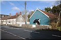
Tin tabernacle in Chewton Mendip
Tin tabernacle and cottages in Chewton Mendip.
Image: © Philip Halling
Taken: 15 Feb 2018
0.06 miles
4

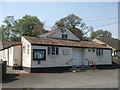
Chewton Mendip social club
Distinctive in materials and colour.
Image: © Neil Owen
Taken: 22 Apr 2019
0.06 miles
5
Chewton Mendip village hall
Also home to the men's club.
Image: © Neil Owen
Taken: 22 Apr 2019
0.06 miles
6
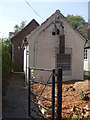
Chewton Mendip telephone exchange
Looking a little clearer after some heavy pruning.
Image: © Neil Owen
Taken: 22 Apr 2019
0.07 miles
7
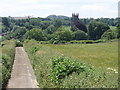
Field land and St Mary Magdalene's - Chewton Mendip
A view over the tower of St Mary Magdalene's church from Field Lane.
Image: © Sharon Loxton
Taken: 11 Jun 2006
0.09 miles
8
Waiting for the bus, at Chewton Mendip
Image: © Roger Cornfoot
Taken: 23 Apr 2010
0.09 miles
9
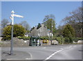
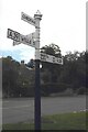
Old Direction Sign - Signpost by the A39, High Street, Chewton Mendip Parish
Pyramid finial - 4 arms; Somerset SCC pyramid by the A39, in parish of Chewton Mendip (Mendip District), junction with the B3114, at crossroads of High Street, Lower Street, Chewton Hill and Cole's Lane. Restored, repainted and the arms mounted in a different order by 2023, see https://www.geograph.org.uk/photo/7568589.
Surveyed
Milestone Society National ID: SO_ST5953B
Image: © Milestone Society
Taken: 1 May 2013
0.09 miles
10
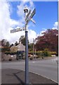
Direction Sign – Signpost on the A39 in Chewton Mendip
Located on the west side of the junction of the A39 High Street and B3114 Lower Street in Chewton Mendip parish. 4 arms and pyramid finial. Restored, repainted and the arms mounted in a different order compared to the 2013 photo, https://www.geograph.org.uk/photo/6043420. Google Street View shows it in place in 2011 and 2012, but not in 2009 and 2021.
Milestone Society National ID: SO_ST5953B
Image: © J Dowding
Taken: 29 Jul 2023
0.09 miles