IMAGES TAKEN NEAR TO
Charlton Road, RADSTOCK, BA3 4AE
Introduction
This page details the photographs taken nearby to Charlton Road, BA3 4AE by members of the Geograph project.
The Geograph project started in 2005 with the aim of publishing, organising and preserving representative images for every square kilometre of Great Britain, Ireland and the Isle of Man.

There are currently over 7.5m images from over14,400 individuals and you can help contribute to the project by visiting https://www.geograph.org.uk
Image Map
Images are licensed for reuse under creativecommons.org/licenses/by-sa/2.0
Notes
- Clicking on the map will re-center to the selected point.
- The higher the marker number, the further away the image location is from the centre of the postcode.
Image Listing (25 Images Found)
Images are licensed for reuse under creativecommons.org/licenses/by-sa/2.0
Image
Details
Distance
1
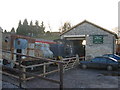
Railway Centre at Midsomer Norton
A view looking west to the engine shed at the railway centre at the old Somerset and Dorset Joint Railway station at Midsomer Norton. An old WWII pillbox can be seen on the hill to the left of the shed roof.
Image: © Phil Williams
Taken: 21 Jan 2006
0.18 miles
2
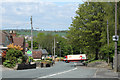
2010 : B3355 Silver Street entering Midsomer Norton
A P&H Retail Distribution vehicle takes advantage of a break in the traffic to emerge from Charlton Street.
Image: © Maurice Pullin
Taken: 10 May 2010
0.19 miles

4
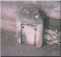
Old Milestone by the A367, Fosseway South, Norton Radstock parish
The milestone is located at the Charlton Crossroads, Midsomer Norton, on the pavement attached to the boundary wall, on the West side of the road. Parish of Norton Radstock (Bath and North East Somerset District). Stone post (plate lost), Bath hands iron plate design, erected by the Bath turnpike trust in the 19th century.
Inscription once read:-
BATH 10 / SHEPTON MALLET 7¼
Milestone Society National ID: SO_RASM10
Image: © JR Dowding
Taken: 31 Dec 2007
0.21 miles
5
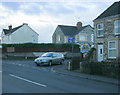
2009 : Junction of the A367 and Charlton Road
The A367 follows the Fosse Way south to Shepton Mallet, Charlton Road heads west away from Charlton. A small convenience store stands opposite.
Image: © Maurice Pullin
Taken: 16 Jan 2009
0.22 miles
6

Missing Railway Bridge
There was a railway bridge here from 1874 to 1966 when the railway closed along with the adjacent Midsomer Norton South station. The station has been restored, but it is unlikely that the bridge will be reinstated. As can be seen, the old track on the other side of the road has been turned into a foot and cycle path. It continues into Radstock, which was the next station.
Image: © mike smith
Taken: 25 Mar 2012
0.22 miles
7
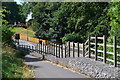
Cycle track descending to Silver Street, Midsomer Norton
The track leaves the trackbed of the former railway to cross the road just below Midsomer Norton South station. The railway line crossed the road on a bridge, now removed. Image shows the view from the other side.
Image: © David Martin
Taken: 2 Aug 2018
0.22 miles
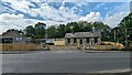
9

Midsomer Norton South station
Headquarters of the Somerset & Dorset Railway Heritage Trust.
Image: © David Martin
Taken: 2 Aug 2018
0.23 miles
10
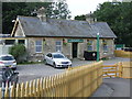
Midsomer Norton South Railway Station building
The station building is now the headquarters of the Somerset & Dorset Railway Trust and accommodates a ticket office and shop selling railway books etc.
Image: © Shaun O'Sullivan
Taken: 26 Aug 2013
0.23 miles