IMAGES TAKEN NEAR TO
Lower Whitelands, RADSTOCK, BA3 3JP
Introduction
This page details the photographs taken nearby to Lower Whitelands, BA3 3JP by members of the Geograph project.
The Geograph project started in 2005 with the aim of publishing, organising and preserving representative images for every square kilometre of Great Britain, Ireland and the Isle of Man.

There are currently over 7.5m images from over14,400 individuals and you can help contribute to the project by visiting https://www.geograph.org.uk
Image Map
Images are licensed for reuse under creativecommons.org/licenses/by-sa/2.0
Notes
- Clicking on the map will re-center to the selected point.
- The higher the marker number, the further away the image location is from the centre of the postcode.
Image Listing (4 Images Found)
Images are licensed for reuse under creativecommons.org/licenses/by-sa/2.0
Image
Details
Distance
1
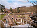
Sewage works
Lower Whitelands is seen behind the trees [top left]; Woodborough Farm nestles between the two evergreen copses in the top right of the picture
Image: © chris wharton n poppi lewis
Taken: 16 Mar 2007
0.14 miles
2
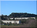
Lower Whitelands, Radstock
Looking North-west from the bed of the disused Bath to Bournemouth Somerset & Dorset Railway (now Sustrans NCN24 Cycleway), Tyning Batch (old coal spoil tip, aforested with Scots Pine & Larch in 1950's) in background. "White lias, I wanna lias, white lias, lias I want!"
Image: © Jon Price
Taken: 24 Jan 2004
0.14 miles
3
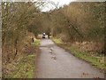
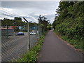
NCN cyclepath 24
The cyclepath follows the Somerset & Dorset Railway line along the valley of the Wellow Brook. Here it approaches the site of Writhlington colliery.
Image: © Derek Harper
Taken: 25 Feb 2009
0.14 miles