
IMAGES TAKEN NEAR TO
South View, RADSTOCK, BA3 3DW
Introduction
This page details the photographs taken nearby to South View, BA3 3DW by members of the Geograph project.
The Geograph project started in 2005 with the aim of publishing, organising and preserving representative images for every square kilometre of Great Britain, Ireland and the Isle of Man.

There are currently over 7.5m images from over14,400 individuals and you can help contribute to the project by visiting https://www.geograph.org.uk
Image Map
Images are licensed for reuse under creativecommons.org/licenses/by-sa/2.0
Notes
- Clicking on the map will re-center to the selected point.
- The higher the marker number, the further away the image location is from the centre of the postcode.
Image Listing (29 Images Found)
Images are licensed for reuse under creativecommons.org/licenses/by-sa/2.0
Image
Details
Distance
1
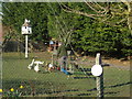
Exotica on Eastdown Road
This free range plot is home to some chickens, geese and peafowl. All seem keen to get a beak-full of grain. This part of Clandown was bathed in unseasonably warm sunshine and there seemed to be dozens of cockerels all down the road in different homes, crowing incessantly.
Image: © Neil Owen
Taken: 25 Feb 2019
0.03 miles
2
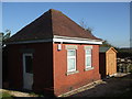
The Old Pump House
This little red brick building used to work on the covered reservoir just behind it. However, the large garden shed is a sign that plans were laid for it to become a private residence.
Image: © Neil Owen
Taken: 25 Feb 2019
0.06 miles
3
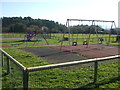
Duchy Road Play area
A nice selection of things for the younger visitors to Clandown Recreation Ground.
Image: © Neil Owen
Taken: 25 Feb 2019
0.13 miles
4

A pitch on Clandown Rec
It's a pair of goals, but the surface is not up to Premiership standard. The old Clandown football club used to play just up the road, but they disbanded over a decade ago.
Image: © Neil Owen
Taken: 25 Feb 2019
0.15 miles
5

A little piece of Roman passage
The Fosse Way is one of Britain's prime Roman routes. The ancient road would have been a little different to today's vision. Once the main A367 was built a short distance away, this lightly-metalled road seems almost forgotten as it runs through Clandown.
Image: © Neil Owen
Taken: 25 Feb 2019
0.15 miles
6

Crossroads, Clandown
Eastdown Road (foreground) meets Northdown Road (right) at the north edge of the village.
Image: © Derek Harper
Taken: 6 Dec 2019
0.16 miles
7

A track beside the sub-station
The footpath runs up the hill, across the A367 and over to Round Hill.
Image: © Neil Owen
Taken: 25 Feb 2019
0.17 miles
8
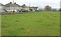
Houses on Northdown Road, Clandown
Looking right from Image
Image: © Derek Harper
Taken: 6 Dec 2019
0.17 miles
9
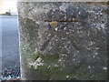
Benchmark on the Lamb Hotel
This old cutmark is listed in the Benchmark Database: https://www.bench-marks.org.uk/bm104978 . See Image] for a view of the hotel.
Image: © Neil Owen
Taken: 25 Feb 2019
0.18 miles
10

Over Clan Down
The footpath goes over the hill from where the village gets its name.
Image: © Neil Owen
Taken: 25 Feb 2019
0.18 miles