IMAGES TAKEN NEAR TO
Fosse Lane, RADSTOCK, BA3 2UZ
Introduction
This page details the photographs taken nearby to Fosse Lane, BA3 2UZ by members of the Geograph project.
The Geograph project started in 2005 with the aim of publishing, organising and preserving representative images for every square kilometre of Great Britain, Ireland and the Isle of Man.

There are currently over 7.5m images from over14,400 individuals and you can help contribute to the project by visiting https://www.geograph.org.uk
Image Map (Loading...)


Getting Data...Please wait
Leaflet Map data © OpenStreetMap
Images are licensed for reuse under creativecommons.org/licenses/by-sa/2.0
Notes
- Clicking on the map will re-center to the selected point.
- The higher the marker number, the further away the image location is from the centre of the postcode.
Image Listing (4 Images Found)
Images are licensed for reuse under creativecommons.org/licenses/by-sa/2.0
Image
Details
Distance
1
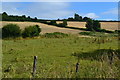
View northeast from former railway route
Image: © David Martin
Taken: 2 Aug 2018
0.13 miles
2
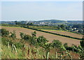
2008 : East from Millard's Hill
Image: © Maurice Pullin
Taken: 20 Sep 2008
0.14 miles
3

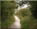
Fosse Lane - the end of the tarmac
At this point Fosse Lane becomes a Byway Open to All Traffic. After 200 metres it reaches a T-junction with the ancient Fosseway (also a BOAT).
Image: © James Ayres
Taken: 28 Aug 2011
0.24 miles
4
Norton Radstock Greenway
This cycleway follows the track of the Bristol and North Somerset Railway, which operated between 1873 and 1968.
Image: © Derek Harper
Taken: 7 Oct 2009
0.25 miles