IMAGES TAKEN NEAR TO
St. Anthonys Close, RADSTOCK, BA3 2UL
Introduction
This page details the photographs taken nearby to St. Anthonys Close, BA3 2UL by members of the Geograph project.
The Geograph project started in 2005 with the aim of publishing, organising and preserving representative images for every square kilometre of Great Britain, Ireland and the Isle of Man.

There are currently over 7.5m images from over14,400 individuals and you can help contribute to the project by visiting https://www.geograph.org.uk
Image Map
Images are licensed for reuse under creativecommons.org/licenses/by-sa/2.0
Notes
- Clicking on the map will re-center to the selected point.
- The higher the marker number, the further away the image location is from the centre of the postcode.
Image Listing (20 Images Found)
Images are licensed for reuse under creativecommons.org/licenses/by-sa/2.0
Image
Details
Distance
1
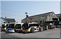
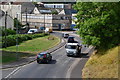
Centurion Travel, West Road, Midsomer Norton
Image: © Roger Cornfoot
Taken: 23 Apr 2010
0.15 miles
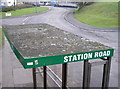
2
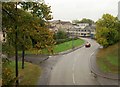
Station Road, Midsomer Norton
Seen from the former railway bridge now carrying the Norton Radstock Greenway along the line of the Bristol and North Somerset Railway, and looking towards centre of Midsomer Norton on a wet day.
Image: © Derek Harper
Taken: 7 Oct 2009
0.17 miles
4
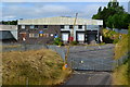
Disused factory site
Former Welton Bibby & Baron paper bag site in Station Road.
Image: © David Martin
Taken: 2 Aug 2018
0.18 miles
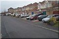
5
Station Road, Midsomer Norton
From the footbridge on the route of the disused railway.
Image: © David Martin
Taken: 2 Aug 2018
0.20 miles
6
Off line!
The footbridge just visible to the left of shot replaced the old railway bridge some time ago, but certain railway apparatus seems to have been retained near to its original location.
Image: © Neil Owen
Taken: 14 Feb 2013
0.21 miles
7
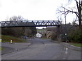
No more steam and soot
The footbridge over Station Road is a modern affair that carries the National Cycle Route 24 and pedestrians. But not so long ago it was a much more substantial structure that saw steam and diesel trains since the founding of the Bristol and North Somerset Railway in 1873. The line was absorbed into the Great Western Railway later on and continued to serve many of the local coal fields until 1964.
Much of the western embankment has been lost and with it a projecting bracket. See Image] for a view from the bridge.
Image: © Neil Owen
Taken: 14 Feb 2013
0.21 miles
8

Norton Radstock Greenway
See Image; this is further west along the cycleway, with the trail running amongst trees to the north of Wellow Brook, and with a link just coming up on the right by the dog bin into housing on Spencer Road.
Image: © Derek Harper
Taken: 7 Oct 2009
0.21 miles
9
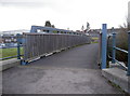
Station Road footbridge
Looking westwards over what was the old railway line. See Image] for a location view.
Image: © Neil Owen
Taken: 14 Feb 2013
0.22 miles
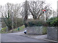
10
Crusty on top
A bus stop shelter, close to some trees and showing the many lichens able to survive in difficult places.
Image: © Neil Owen
Taken: 14 Feb 2013
0.22 miles