IMAGES TAKEN NEAR TO
Somer Road, RADSTOCK, BA3 2SA
Introduction
This page details the photographs taken nearby to Somer Road, BA3 2SA by members of the Geograph project.
The Geograph project started in 2005 with the aim of publishing, organising and preserving representative images for every square kilometre of Great Britain, Ireland and the Isle of Man.

There are currently over 7.5m images from over14,400 individuals and you can help contribute to the project by visiting https://www.geograph.org.uk
Image Map (Loading...)


Getting Data...Please wait
Leaflet Map data © OpenStreetMap
Images are licensed for reuse under creativecommons.org/licenses/by-sa/2.0
Notes
- Clicking on the map will re-center to the selected point.
- The higher the marker number, the further away the image location is from the centre of the postcode.
Image Listing (10 Images Found)
Images are licensed for reuse under creativecommons.org/licenses/by-sa/2.0
Image
Details
Distance
1

2009 : B3355 looking south crossing Thicketmead Bridge
Image: © Maurice Pullin
Taken: 10 Oct 2009
0.18 miles
2
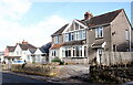
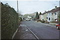
Houses on Northmead Rd
These houses are on the east side of Northmead Rd, the B3355 extension of Palton Rd running north out of Midsomer Norton.
Image: © Nigel Mykura
Taken: 2 Nov 2020
0.18 miles
4
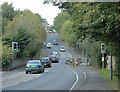
2009 : B3355 Northmead Road, Midsomer Norton
The bridge at the bottom over a small brook has caused holdups over many a long year. About time it was widened.
Image] gives a far more pleasant view from the other side of the bridge.
The old Norton/Radstock railway ran through here, it made a link to Bristol via Clutton and Whitchurch. In the other direction (east) it went through Wellow and Limpley Stoke.
Image: © Maurice Pullin
Taken: 10 Oct 2009
0.19 miles
6
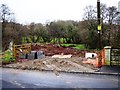
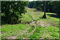
Meadow by Wellow Brook
From a gate on Northmead Road (the B3355) close to Thicketmead Bridge across the brook. A public footpath runs along the linear meadow between the Norton Radstock Greenway (on the left) and the tree-lined brook to the right.
Image: © Derek Harper
Taken: 7 Oct 2009
0.22 miles
7
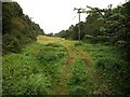
High Meadows, Midsomer Norton
With Paulton Batch in the distance
Image: © Dominic Dawn Harry and Jacob Paterson
Taken: 18 Feb 2006
0.24 miles

9

View down Hayes Park Road
With the prominent Old Mills Batch, a mining spoil heap, on the horizon.
Image: © David Martin
Taken: 2 Aug 2018
0.25 miles