
IMAGES TAKEN NEAR TO
Parkway, RADSTOCK, BA3 2HD
Introduction
This page details the photographs taken nearby to Parkway, BA3 2HD by members of the Geograph project.
The Geograph project started in 2005 with the aim of publishing, organising and preserving representative images for every square kilometre of Great Britain, Ireland and the Isle of Man.

There are currently over 7.5m images from over14,400 individuals and you can help contribute to the project by visiting https://www.geograph.org.uk
Image Map
Images are licensed for reuse under creativecommons.org/licenses/by-sa/2.0
Notes
- Clicking on the map will re-center to the selected point.
- The higher the marker number, the further away the image location is from the centre of the postcode.
Image Listing (43 Images Found)
Images are licensed for reuse under creativecommons.org/licenses/by-sa/2.0
Image
Details
Distance
1
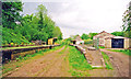
Midsomer Norton & Welton South station, under restoration 2001
View NE, towards Bath: ex-S&D Joint main line Bath - Evercreech Junction - Templecombe -Bournemouth West, closed 7/3/66. The station and some track-bed were acquired by the Somerset & Dorset Railway Heritage Trust in 1992 [?]; since 2001 they have relaid track towards Chilcompton and are running trains. See http://www.sdjr.co.uk/ . See also Image] and Image
Image: © Ben Brooksbank
Taken: 15 May 2001
0.06 miles
2
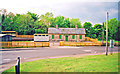
Midsomer Norton & Welton South station, during restoration 2001
View NW of the exterior on the Down side of the former S&D Joint station, closed 7/3/66, under restoration by the Somerset & Dorset Joint Railway Heritage Trust. (See also Image] and cf. Image]).
Image: © Ben Brooksbank
Taken: 15 May 2001
0.06 miles
3
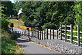
Cycle track descending to Silver Street, Midsomer Norton
The track leaves the trackbed of the former railway to cross the road just below Midsomer Norton South station. The railway line crossed the road on a bridge, now removed. Image shows the view from the other side.
Image: © David Martin
Taken: 2 Aug 2018
0.07 miles
4
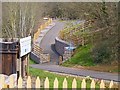
Missing Railway Bridge
There was a railway bridge here from 1874 to 1966 when the railway closed along with the adjacent Midsomer Norton South station. The station has been restored, but it is unlikely that the bridge will be reinstated. As can be seen, the old track on the other side of the road has been turned into a foot and cycle path. It continues into Radstock, which was the next station.
Image: © mike smith
Taken: 25 Mar 2012
0.07 miles
5
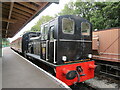
D2128 at Midsomer Norton
A re-engined Class O3 locomotive https://sdjr.co.uk/locomotives-stock/d2128-03901
Image: © Jonathan Thacker
Taken: 23 Sep 2021
0.07 miles
6

Restored station building, Midsomer Norton
Once on the Somerset and Dorset Joint Railway https://en.wikipedia.org/wiki/Somerset_and_Dorset_Joint_Railway between Bath and Bournemouth.
Image: © Jonathan Thacker
Taken: 23 Sep 2021
0.07 miles
7
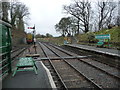
Southern end, Midsomer Norton South station
So good to see an informative notice, rather than a simple prohibition.
Image: © Christine Johnstone
Taken: 2 Apr 2018
0.08 miles
8
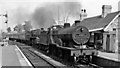
Midsomer Norton South Station, with Down express
View NE, towards Bath; Somerset & Dorset Joint line (Bath Green Park - Bournemouth West). The 09.35 Sheffield (Midland) to Bournemouth West Summer Saturday express is headed by LMS 2P 4-4-0 No. 40569 piloting BR Standard 5MT 4-6-0 No. 73051 and is attacking the 8 miles at 1-in-50/60 climb up from Radstock to the Mendips summit at Masbury. The station closed on 7/3/66 along with the whole S&D line, but since 1992 has become the headquarters of the Somerset & Dorset Heritage Trust, who now run trains part of the way up towards Chilcompton.
Image: © Ben Brooksbank
Taken: 22 Aug 1959
0.08 miles
10

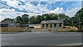
Midsomer Norton South station
Headquarters of the Somerset & Dorset Railway Heritage Trust.
Image: © David Martin
Taken: 2 Aug 2018
0.08 miles