IMAGES TAKEN NEAR TO
Wellow Brook Meadow, RADSTOCK, BA3 2BQ
Introduction
This page details the photographs taken nearby to Wellow Brook Meadow, BA3 2BQ by members of the Geograph project.
The Geograph project started in 2005 with the aim of publishing, organising and preserving representative images for every square kilometre of Great Britain, Ireland and the Isle of Man.

There are currently over 7.5m images from over14,400 individuals and you can help contribute to the project by visiting https://www.geograph.org.uk
Image Map (22 Images)


Getting Data...Please wait
Leaflet Map data © OpenStreetMap
Images are licensed for reuse under creativecommons.org/licenses/by-sa/2.0
Notes
- Clicking on the map will re-center to the selected point.
- The higher the marker number, the further away the image location is from the centre of the postcode.
Image Listing (22 Images Found)
Images are licensed for reuse under creativecommons.org/licenses/by-sa/2.0
Image
Details
Distance
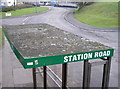
1
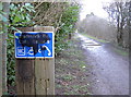
Repairs when you need them
Disregarding the inevitable vandalism, perhaps cyclists suffer more frequently than otherwise expected. Is there a particularly bad spot?
Image: © Neil Owen
Taken: 14 Feb 2013
0.03 miles
2

The Greener Way
Many old railway lines are now usefully converted into cycleroutes and motor vehicle-free pathways. This was the old section of the Five Arches line between Midsomer and Radstock, but is now part of National Route 24. It's known as the Norton-Radstock Greenway; with substantial lottery funding it has been opened up to allow pupils of Norton School to travel without using the roads.
Image: © Neil Owen
Taken: 14 Feb 2013
0.03 miles
3
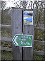
Cycling adventures
A poster on the Norton Radstock Greenway, advertising local tours and rides.
Image: © Neil Owen
Taken: 14 Feb 2013
0.03 miles
4
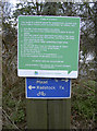
Code of Conduct
Just in case there is any doubt or uncertainties this notice sets out what is expected of users of the cyclepath. Pity it has partly obscured the mileage marker.
Image: © Neil Owen
Taken: 14 Feb 2013
0.03 miles
5
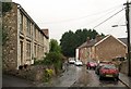
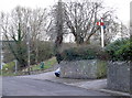
Millard's Hill, Welton
The foot of the hill in steady rain. By the time it has reached the junction with Station Road and West Road (the A382) behind the white end terrace it has crossed into Image
Image: © Derek Harper
Taken: 7 Oct 2009
0.04 miles
6
Off line!
The footbridge just visible to the left of shot replaced the old railway bridge some time ago, but certain railway apparatus seems to have been retained near to its original location.
Image: © Neil Owen
Taken: 14 Feb 2013
0.04 miles
7
Retained features
The old wall of the former GWR line bridge at Station Road has been kept but the new working to turn it into a cyclepath is a simple concrete mass.
Image: © Neil Owen
Taken: 14 Feb 2013
0.04 miles
8
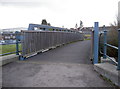
Station Road footbridge
Looking westwards over what was the old railway line. See Image] for a location view.
Image: © Neil Owen
Taken: 14 Feb 2013
0.05 miles
9
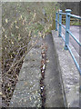
Crusty on top
A bus stop shelter, close to some trees and showing the many lichens able to survive in difficult places.
Image: © Neil Owen
Taken: 14 Feb 2013
0.05 miles
10
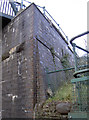
A brick buttress
The old railway line has been gone for many years now, but the major part of the eastern side of the bridge in Station Road remains to remind travellers of its past. Modern (and lighter) railings are of no burden.
Image: © Neil Owen
Taken: 14 Feb 2013
0.05 miles