IMAGES TAKEN NEAR TO
Burlington Road, RADSTOCK, BA3 2AF
Introduction
This page details the photographs taken nearby to Burlington Road, BA3 2AF by members of the Geograph project.
The Geograph project started in 2005 with the aim of publishing, organising and preserving representative images for every square kilometre of Great Britain, Ireland and the Isle of Man.

There are currently over 7.5m images from over14,400 individuals and you can help contribute to the project by visiting https://www.geograph.org.uk
Image Map (Loading...)


Getting Data...Please wait
Leaflet Map data © OpenStreetMap
Images are licensed for reuse under creativecommons.org/licenses/by-sa/2.0
Notes
- Clicking on the map will re-center to the selected point.
- The higher the marker number, the further away the image location is from the centre of the postcode.
Image Listing (16 Images Found)
Images are licensed for reuse under creativecommons.org/licenses/by-sa/2.0
Image
Details
Distance
1
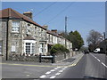
Corner of Burlington Road, Midsomer Norton
Image: © Roger Cornfoot
Taken: 23 Apr 2010
0.04 miles
2
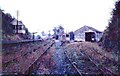
Midsomer Norton Railway Station
Disused station buildings and signal box.
Image: © Tudor Williams
Taken: 16 Sep 1967
0.16 miles
3
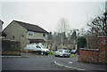
Wheelers Road, Midsomer Norton
Image: © Dominic Dawn Harry and Jacob Paterson
Taken: 19 Feb 2006
0.17 miles
4
Hanging displays
The Wellow Brook runs down the valley towards Radstock, with some interesting and varied decorations. See Image] for a look the other way for a grazing duck.
Image: © Neil Owen
Taken: 14 Feb 2013
0.19 miles
5
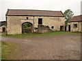
Barn, Welton
At Manor Farm, by the footpath from Norton Radstock Greenway to Millard's Hill. "C18, possibly earlier. Two builds. Two storeys, limestone rubble with pantile roof and coped verges with saddle-stones. Large segmental headed through archway to left of centre with small window over with chamfered reveals" http://www.imagesofengland.org.uk/Details/Default.aspx?id=31961&mode=adv .
Image: © Derek Harper
Taken: 7 Oct 2009
0.20 miles
6

View across to Wheeler's Hill
From the former railway line between Radstock and Midsomer Norton South.
Image: © David Martin
Taken: 2 Aug 2018
0.21 miles
7
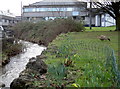
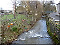
Wellow Brook
The small stream flows down towards Wheelers Hill and under Station Road in the background. Despite being so close to a busy road the wildlife don't seem to be unduly disturbed. See Image] for a look in the downstream direction.
Image: © Neil Owen
Taken: 14 Feb 2013
0.22 miles
8
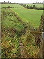
Footpath from Norton Radstock Greenway
A flight of steps descends the embankment on the north side of the former Bristol and North Somerset Railway. The path then turns left towards Welton. Further up the hillside, Fosse Lane crosses the image, marked by the field boundary.
Image: © Derek Harper
Taken: 7 Oct 2009
0.22 miles
9

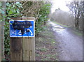
The Greener Way
Many old railway lines are now usefully converted into cycleroutes and motor vehicle-free pathways. This was the old section of the Five Arches line between Midsomer and Radstock, but is now part of National Route 24. It's known as the Norton-Radstock Greenway; with substantial lottery funding it has been opened up to allow pupils of Norton School to travel without using the roads.
Image: © Neil Owen
Taken: 14 Feb 2013
0.22 miles
10
Repairs when you need them
Disregarding the inevitable vandalism, perhaps cyclists suffer more frequently than otherwise expected. Is there a particularly bad spot?
Image: © Neil Owen
Taken: 14 Feb 2013
0.22 miles