IMAGES TAKEN NEAR TO
Wilmington, BATH, BA2 9JB
Introduction
This page details the photographs taken nearby to BA2 9JB by members of the Geograph project.
The Geograph project started in 2005 with the aim of publishing, organising and preserving representative images for every square kilometre of Great Britain, Ireland and the Isle of Man.

There are currently over 7.5m images from over14,400 individuals and you can help contribute to the project by visiting https://www.geograph.org.uk
Image Map
Images are licensed for reuse under creativecommons.org/licenses/by-sa/2.0
Notes
- Clicking on the map will re-center to the selected point.
- The higher the marker number, the further away the image location is from the centre of the postcode.
Image Listing (13 Images Found)
Images are licensed for reuse under creativecommons.org/licenses/by-sa/2.0
Image
Details
Distance
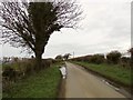
1
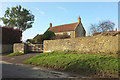
Farmhouse, Wilmington
Looking the other way from Image Footpath BA 20/13#2 leaves the lane here to run oast the farm.
Image: © Derek Harper
Taken: 9 Dec 2019
0.00 miles
2
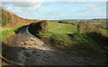
Gateway, Wilmington
The gate from which Image was taken. On the right is a green lane to Inglesbatch. The lane leads to Clays End.
Image: © Derek Harper
Taken: 9 Dec 2019
0.03 miles
3
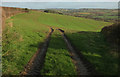
Field, Wilmington
The wedge-shaped corner of a field between the lane to Pennsylvania Farm on the left and a green lane to Inglesbatch, with a view towards Bath.
Image: © Derek Harper
Taken: 9 Dec 2019
0.08 miles
4
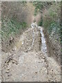
Wilmington Lane
The lane is, at best, a dirt track without metalling. At this particular point the damage caused by vehicles and weather has created some severe drops and rocky patches. Passable by a Land Rover or a trials bike with care, but little else.
Image: © Neil Owen
Taken: 6 Mar 2021
0.11 miles
5
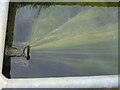
Sucking in the weed
A cattle trough is being topped up constantly and the overflow taken by this pipe. However, the build-up of weed is also being drawn into the drain in long flowing strands. See Image] for a wider look.
Image: © Neil Owen
Taken: 6 Mar 2021
0.11 miles
6
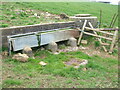
Water trough near Wilmington Farm
Some heavy drainage structures and a cattle trough lie down the hill from the farm. Being fed constantly has brought some issues - see Image
Image: © Neil Owen
Taken: 6 Mar 2021
0.11 miles
7

2008 : South east from Wilmington
After the field of wheat stubble we look across the valley to Inglesbatch and Priston. The buildings on the skyline to the right belong to Tunley, which stands at the top of a ridge.
Image: © Maurice Pullin
Taken: 16 Oct 2008
0.13 miles
8
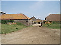
Wilmington Farm
Outbuilding of Wilmington Farm.
Image: © Sharon Loxton
Taken: 2 Jul 2006
0.14 miles
9
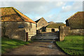
Wilmington Farm
Attractive farm buildings on the west side of the hamlet.
Image: © Derek Harper
Taken: 9 Dec 2019
0.15 miles
10
Road to Newton St Loe
This ridge road is, briefly here, the parish boundary between Marksbury (left) and Priston.
Image: © Derek Harper
Taken: 16 Feb 2016
0.20 miles