IMAGES TAKEN NEAR TO
Marksbury, BATH, BA2 9HR
Introduction
This page details the photographs taken nearby to BA2 9HR by members of the Geograph project.
The Geograph project started in 2005 with the aim of publishing, organising and preserving representative images for every square kilometre of Great Britain, Ireland and the Isle of Man.

There are currently over 7.5m images from over14,400 individuals and you can help contribute to the project by visiting https://www.geograph.org.uk
Image Map
Images are licensed for reuse under creativecommons.org/licenses/by-sa/2.0
Notes
- Clicking on the map will re-center to the selected point.
- The higher the marker number, the further away the image location is from the centre of the postcode.
Image Listing (45 Images Found)
Images are licensed for reuse under creativecommons.org/licenses/by-sa/2.0
Image
Details
Distance
1
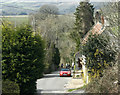
2009 : Lane to Marksbury Vale
Via Court Farm.
Most of the village is at the top of the hill, along the old main road, though a little spills over.
Somerset scenery south of Keynsham in the background.
Image: © Maurice Pullin
Taken: 15 Mar 2009
0.03 miles
2
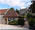
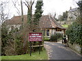
The Chapel, Marksbury
Now used as a smart holiday let. How times change....
See also Image
Image: © Rick Crowley
Taken: 17 Jul 2020
0.03 miles
3
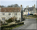
Marksbury, Somerset.
Showing the West side of the village, taken at the South West of Court Farm.
Image: © Rick Crowley
Taken: 22 Feb 2009
0.04 miles
4
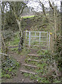
Over the flank of Winsbury Hill
This path leaves the road to Court Farm and heads towards the locally prominent Winsbury Hill, of which this land forms a small prominence.
Image: © Neil Owen
Taken: 15 Mar 2016
0.05 miles
5
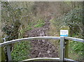
Improved version
The sign says this footpath has been improved by Bath and North East Somerset Council.
Image: © Neil Owen
Taken: 15 Mar 2016
0.05 miles
6
Marksbury Methodist church
The village was served by this Methodist church for many years but is now a private residence.
Image: © Neil Owen
Taken: 15 Mar 2016
0.05 miles
7
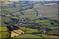
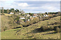
Bath And North East Somerset : Marksbury Scenery
Looking towards the village of Marksbury with Farmborough behind it.
Image: © Lewis Clarke
Taken: 18 Jun 2017
0.07 miles
8
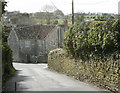
2009 : The old main road, Marksbury
The A39 which is behind us, is merely a bypass. This is Marksbury proper.
Image: © Maurice Pullin
Taken: 15 Mar 2009
0.08 miles
9
2009 : Main Street, Marksbury
Another village with the benefit of a good bypass.
"MARKSBURY, a parish in the hundred of Keynsham, county Somerset, 7 miles S.W. of Bath, its post town, and 4 S. of the Keynsham railway station. The parish, which is of small extent, is chiefly agricultural, and includes the hamlet of Hound-street. The soil consists of loam and stone brash, with a subsoil of marl. Coal is found. The surface is hilly, and the lower grounds are watered by several rivulets. On Wingsbury Hill are remains of an ancient chapel, probably belonging to a monastery, which formerly existed here. The living is a rectory* in the diocese of Bath and Wells, value £240. The church, dedicated to St. Peter, is an ancient structure, with a tower containing six bells. There is a National school for both sexes, also a Sunday-school. There is a place of worship for the Wesleyans." From The National Gazetteer of Great Britain and Ireland (1868) Transcribed by Colin Hinson © 2003
The above was copied from: http://www.genuki.org.uk/big/eng/SOM/Marksbury/index.html
More up to date information is to be found in http://www.thelocalchannel.co.uk/Marksbury/home.aspx
and http://www.visionofbritain.org.uk/place/place_page.jsp?p_id=13094&st=Marksbury
Image: © Maurice Pullin
Taken: 15 Mar 2009
0.08 miles
10
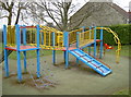
Marksbury play ground
Right next to the village hall.
Image: © Neil Owen
Taken: 15 Mar 2016
0.09 miles