IMAGES TAKEN NEAR TO
Roman Way, BATH, BA2 8SG
Introduction
This page details the photographs taken nearby to Roman Way, BA2 8SG by members of the Geograph project.
The Geograph project started in 2005 with the aim of publishing, organising and preserving representative images for every square kilometre of Great Britain, Ireland and the Isle of Man.

There are currently over 7.5m images from over14,400 individuals and you can help contribute to the project by visiting https://www.geograph.org.uk
Image Map
Images are licensed for reuse under creativecommons.org/licenses/by-sa/2.0
Notes
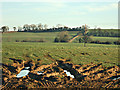
- Clicking on the map will re-center to the selected point.
- The higher the marker number, the further away the image location is from the centre of the postcode.
Image Listing (16 Images Found)
Images are licensed for reuse under creativecommons.org/licenses/by-sa/2.0
Image
Details
Distance
1
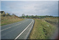
A367 Peasedown Bypass
Image: © Dominic Dawn Harry and Jacob Paterson
Taken: 19 Feb 2006
0.07 miles
2
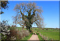
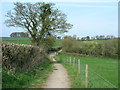
Footpath near Peasdown St John
View along a footpath near Peasdown St John.
Image: © Wayland Smith
Taken: 2 Apr 2021
0.12 miles
3
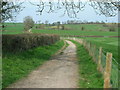
End of the Byway
The gate where the BOAT ends and meets the tarmac lane to Double Hill.
Image: © James Ayres
Taken: 10 Apr 2010
0.13 miles
4
Western end of the Byway over White Ox Mead Knoll
View roughly north-eastwards from just inside the gate where the Byway leaves the tarmac. This Byway has an excellent hard surface and is well maintained.
Image: © James Ayres
Taken: 10 Apr 2010
0.13 miles
5
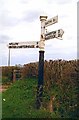
Old Direction Sign - Signpost by Wellow Road, Shoscombe Parish
Pyramid finial - 4 arms; Somerset SCC pyramid by the UC road, in parish of Shoscombe (Bath and North East Somerset District), Hang Hill junction with Wellow Road.
Surveyed
Milestone Society National ID: SO_ST7156
Image: © J Dowding
Taken: Unknown
0.16 miles
6
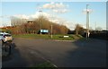
Foxcote Avenue, Peasedown St John
The entrance to what is labelled opposite as Bath Business Park, although it's a fair step from Bath. The building in the background is the private CircleBath Hospital.
Image: © Derek Harper
Taken: 23 Feb 2016
0.17 miles
7
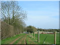
Heading towards White Ox Mead Knoll
The first gate encountered on the Byway travelling from west to east.
Image: © James Ayres
Taken: 10 Apr 2010
0.17 miles
8
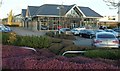
Car showroom, Peasedown St John
The Mercedes-Benz showroom on the business park, seen from the side of the roundabout shown in Image
Image: © Derek Harper
Taken: 23 Feb 2016
0.18 miles
9
2008 : Field entrance near Peasedown
A good frost that morning to break down the surface soil and kill some of the bugs.
Image: © Maurice Pullin
Taken: 9 Feb 2008
0.18 miles
10
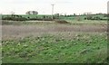
Near Peasedown St John
Looking north from Wellow Road towards the ring of trees on White Ox Mill Knoll. I get the impression that the bank-bounded site in the foreground has been earmarked as part of the spreading industrial estate on the south edge of Peasedown St John, but hasn't yet been developed.
Image: © Derek Harper
Taken: 23 Feb 2016
0.19 miles