IMAGES TAKEN NEAR TO
/High Street, BATH, BA2 8QQ
Introduction
This page details the photographs taken nearby to /High Street, BA2 8QQ by members of the Geograph project.
The Geograph project started in 2005 with the aim of publishing, organising and preserving representative images for every square kilometre of Great Britain, Ireland and the Isle of Man.

There are currently over 7.5m images from over14,400 individuals and you can help contribute to the project by visiting https://www.geograph.org.uk
Image Map
Images are licensed for reuse under creativecommons.org/licenses/by-sa/2.0
Notes
- Clicking on the map will re-center to the selected point.
- The higher the marker number, the further away the image location is from the centre of the postcode.
Image Listing (107 Images Found)
Images are licensed for reuse under creativecommons.org/licenses/by-sa/2.0
Image
Details
Distance
1
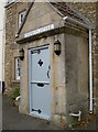
Footman's Cottage
On Wellow's High Street.
Image: © Neil Owen
Taken: 25 Oct 2018
0.01 miles
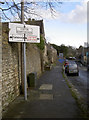
2
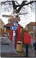
Old Direction Sign - Signpost by Bath Hill, Wellow parish
Pyramid finial - 2 arms; Somerset SCC pyramid by the UC road, in parish of Wellow (Bath and North East Somerset District), Bath Hill, junction with The Square.
Surveyed
Milestone Society National ID: SO_ST7358
Image: © Milestone Society
Taken: Unknown
0.01 miles
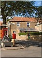
3
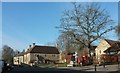
The Square, Wellow
Something of a village focus, with the bus stop, postbox (Elizabeth II, BA2 271 Image), waste bin, signpost Image, telephone box (a K6 listed: https://www.historicengland.org.uk/listing/the-list/list-entry/1115356 ) and memorial bench upon which I sat for a rest; see Image and Image for the drinking fountain behind it. The first building past the Square on the left is Weaver's Farmhouse, described at https://www.historicengland.org.uk/listing/the-list/list-entry/1115336 .
Image: © Derek Harper
Taken: 24 Feb 2016
0.02 miles
4
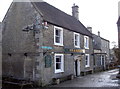
The Fox and Badger
Wellow's principle watering hole. On the closest corner is an old benchmark, dating back to the eighteenth century - see Image And as it happens the lane does lead down to what remains of the old S&D railway.
Image: © Neil Owen
Taken: 24 Feb 2014
0.02 miles
5
Pub benchmark
A cutmark on the Fox and Badger in Wellow; see Image] for a wider view and http://www.bench-marks.org.uk/bm54786 for the entry in the Benchmark Database.
Image: © Neil Owen
Taken: 24 Feb 2014
0.02 miles
6
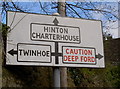
Red spells danger
An old traffic sign, giving a little more emphasis to the watery hazard. See Image] for a wider view. It is a Royal Labels Factory product.
Image: © Neil Owen
Taken: 24 Feb 2014
0.02 miles
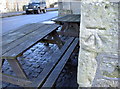
7
Wellow High Street
Watch out for the water! See Image] for a closer look at this well-tended sign.
Image: © Neil Owen
Taken: 24 Feb 2014
0.02 miles
8
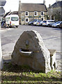
Wet seat
A small fountain on one side, a bench on the other. See Image] for a closer look at the face.
Image: © Neil Owen
Taken: 24 Feb 2014
0.02 miles
9
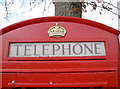
Spruced up
A familiar telephone box showing that someone still loves it.
Image: © Neil Owen
Taken: 24 Feb 2014
0.02 miles
10
Type K6 Telephone Kiosk & memorial trough
The seat was originally a water trough. There is a drinking water fountain on the other side of the stone (see Image).
Image: © Jeff Tomlinson
Taken: 25 Aug 2006
0.02 miles