IMAGES TAKEN NEAR TO
Double Hill, BATH, BA2 8PT
Introduction
This page details the photographs taken nearby to Double Hill, BA2 8PT by members of the Geograph project.
The Geograph project started in 2005 with the aim of publishing, organising and preserving representative images for every square kilometre of Great Britain, Ireland and the Isle of Man.

There are currently over 7.5m images from over14,400 individuals and you can help contribute to the project by visiting https://www.geograph.org.uk
Image Map
Images are licensed for reuse under creativecommons.org/licenses/by-sa/2.0
Notes
- Clicking on the map will re-center to the selected point.
- The higher the marker number, the further away the image location is from the centre of the postcode.
Image Listing (20 Images Found)
Images are licensed for reuse under creativecommons.org/licenses/by-sa/2.0
Image
Details
Distance
1
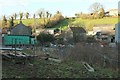
Double Hill Farm
Approaching Wellow Road, having just negotiated the fourth-muddiest field I ever remember walking - and that is saying something. What you see in the foreground is nothing. This is sort of footpath BA 23/8#2, but the line of it on the map goes straight through a barn; needless to say there's no waymarking I can find. Fortunately the bus driver who let me on his vehicle at Peasedown St John didn't notice the state of my boots.
Image: © Derek Harper
Taken: 23 Feb 2016
0.02 miles
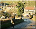
2
2008 : Near Double Hill Farm, Peasedown St. John
If it's pretty you want look the other way. Image]
Taken at the bottom of the hill outside Double Hill Farm - well it has to go somewhere.
Image: © Maurice Pullin
Taken: 9 Feb 2008
0.02 miles
3
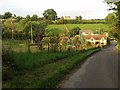
Hillside, Double Hill
From Wellow Road beside Double Hill Farm. On the top of the slope is Bourne Farm.
Image: © Derek Harper
Taken: 23 Feb 2016
0.03 miles
4
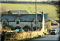
Double Hill
A view of the cottage shown in Image from the west, on Wellow Road. Double Hill Farm is beyond, in the dip, with Bourne Farm on the hill above.
Image: © Derek Harper
Taken: 25 Aug 2008
0.04 miles
5
2008 : Cottage at Double Hill
Double Hill Farm is on Wellow Road between Peasedown and Wellow.
Image: © Maurice Pullin
Taken: 9 Feb 2008
0.04 miles
6
2008 : Double Hill Farm near Peasedown St. John
Switch on the camera - a quick squint through the viewfinder - set the zoom - just in time to catch the horse and rider.
Half way up the western hill at Double Hill.
Image: © Maurice Pullin
Taken: 9 Feb 2008
0.05 miles
7
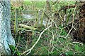
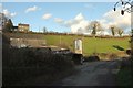
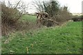
Obstructed stile near Double Hill
Footpath BA 23/8#2 crosses this stile, but it's not worth the struggle to get through the obstructing branches when there's a gate not far to the left.
Image: © Derek Harper
Taken: 23 Feb 2016
0.11 miles
8
Path to Double Hill
Footpath BA 23/8#2, as seen from the other direction in Image The barn at Double Hill Farm is in Image
Image: © Derek Harper
Taken: 23 Feb 2016
0.12 miles
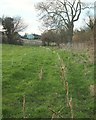
9
Path from Double Hill
Footpath BA 23/8#2 runs along the side of a stream; here you see one of the more acceptable stretches. Each time it crosses a field boundary descending the valley side there is a problem: standing water, thick wet mud, or, in the case of a stile close by me, a branch blocking access to it. At the northwest end is a muddy pasture trampled into awkwardness and with no waymarks I could find. Wear wellies. The stream is an unnamed tributary of the Wellow Brook.
Image: © Derek Harper
Taken: 23 Feb 2016
0.13 miles
10
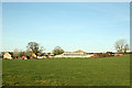
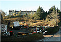
2008 : Bourne Farm, near Peasedown St. John
Appears to be mixed farming here, some arable some dairy.
Image: © Maurice Pullin
Taken: 9 Feb 2008
0.13 miles