IMAGES TAKEN NEAR TO
Dunkerton, BATH, BA2 8BZ
Introduction
This page details the photographs taken nearby to BA2 8BZ by members of the Geograph project.
The Geograph project started in 2005 with the aim of publishing, organising and preserving representative images for every square kilometre of Great Britain, Ireland and the Isle of Man.

There are currently over 7.5m images from over14,400 individuals and you can help contribute to the project by visiting https://www.geograph.org.uk
Image Map
Images are licensed for reuse under creativecommons.org/licenses/by-sa/2.0
Notes
- Clicking on the map will re-center to the selected point.
- The higher the marker number, the further away the image location is from the centre of the postcode.
Image Listing (14 Images Found)
Images are licensed for reuse under creativecommons.org/licenses/by-sa/2.0
Image
Details
Distance
1

Ten Acre Cottages
A pair of cottages by the lane from Crossways to Inglesbatch. The barn with the hipped roof straddles a northing grid line.
Image: © Derek Harper
Taken: 16 Feb 2016
0.00 miles
2

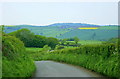
Lane to Inglesbatch
Just north of the cottages shown in Image], with the lane crossing a broad ridge to drop into the Conygre Brook valley.
Image: © Derek Harper
Taken: 16 Feb 2016
0.05 miles
3
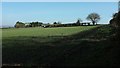
Towards Ashes Hill Farm
Across farmland from beside the tree on the lane shown in Image
Image: © Derek Harper
Taken: 16 Feb 2016
0.07 miles
4
2008 : Lane to Inglesbatch
Inglesbatch itself is hidden by the trees, the place in the distance is Wilmington.
Image: © Maurice Pullin
Taken: 10 May 2008
0.09 miles
5
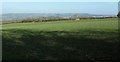
Farmland at Ashes Hill Farm
Looking right from the spot where Image] was taken. The outskirts of Bath at Southdown are in the distance.
Image: © Derek Harper
Taken: 16 Feb 2016
0.14 miles
6
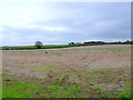
Stubblefield near Englishcombe
Nothing had been done to this field since the harvest earlier in the year and the weeds were starting to show through the stubble. The house in the centre is just south of Kilkenny Lane.
Image: © Nigel Mykura
Taken: 30 Sep 2012
0.17 miles
7

View near Ashes Hill Farm
From the same gateway as Image], looking left. The distant farm right of centre is Pennsylvania Farm, in Image
Image: © Derek Harper
Taken: 16 Feb 2016
0.17 miles
8

2008 : From the lane to Inglesbatch
Looking north near Ten Acre Cottages with a cow pasture before us and Beckford's Tower on Lansdown Image on the skyline. Englishcombe is between.
Image: © Maurice Pullin
Taken: 10 May 2008
0.18 miles
9

Towards Duncorn Hill
From a lane ESE of Inglesbatch; this large field runs behind Manor House Farm.
Image: © Derek Harper
Taken: 16 Feb 2016
0.18 miles
10

Lane to Inglesbatch
Dropping between hedges towards the Conygre Brook valley, with a little patch of trees on the left. Down the lane is Beaufort Farm; across the valley is the farming of hamlet of Wilmington. The distant wooded hill is Stantonbury.
Image: © Derek Harper
Taken: 16 Feb 2016
0.19 miles