IMAGES TAKEN NEAR TO
Dunkerton, BATH, BA2 8BL
Introduction
This page details the photographs taken nearby to BA2 8BL by members of the Geograph project.
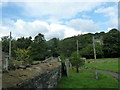
The Geograph project started in 2005 with the aim of publishing, organising and preserving representative images for every square kilometre of Great Britain, Ireland and the Isle of Man.

There are currently over 7.5m images from over14,400 individuals and you can help contribute to the project by visiting https://www.geograph.org.uk
Image Map
Images are licensed for reuse under creativecommons.org/licenses/by-sa/2.0
Notes
- Clicking on the map will re-center to the selected point.
- The higher the marker number, the further away the image location is from the centre of the postcode.
Image Listing (42 Images Found)
Images are licensed for reuse under creativecommons.org/licenses/by-sa/2.0
Image
Details
Distance
1
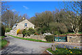
The Hollow
Dwelling on the edge of Dunkerton.
Image: © Wayland Smith
Taken: 2 Apr 2021
0.05 miles
2
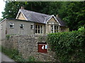
The hall in The Hollow
Dunkerton Parish Hall stands close to where the Somerset Coal Canal used to form a horse-shoe around the village - it used a tunnel here. The hall was originally the school.
Image: © Neil Owen
Taken: 9 Jun 2020
0.05 miles
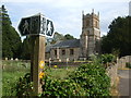
3
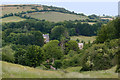
Dunkerton Church Tower. Quintessential England
Church of All Saints, Dunkerton, Somerset. View from a footpath descending a hill from the south. The church is 14th century and the tower 15th.
https://en.wikipedia.org/wiki/Church_of_All_Saints,_Dunkerton
Image: © Rick Crowley
Taken: 8 Jun 2020
0.06 miles
4
From the coal statue to the coal canal (42)
Leaving Dunkerton Churchyard
Image: © Basher Eyre
Taken: 14 Sep 2013
0.07 miles
5
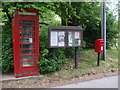
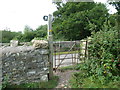
Three ways of reading
The information point of Dunkerton, with the telephone box being a bit of a red herring. Not only is it not actually equipped with a phone (it being a library now) but it was only put here a few years ago. The village has never had a telephone here!
Image: © Neil Owen
Taken: 9 Jun 2020
0.07 miles
7
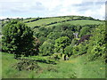
Down the valley to Dunkerton
The footpath leads down the slopes south of the village, affording a fine view. The old rectory building peeps out from the hedges.
Image: © Neil Owen
Taken: 24 May 2022
0.08 miles
8
Follow the Cam Brook or go to church
The paths around Dunkerton offer plenty of diversity, including the Limestone Link path.
Image: © Neil Owen
Taken: 9 Jun 2020
0.08 miles
9
From the coal statue to the coal canal (41)
In Dunkerton churchyard
Image: © Basher Eyre
Taken: 14 Sep 2013
0.08 miles
10
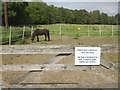
Other reasons for social distancing
This horse appears to be an unfriendly soul. At least he won't be part of the Covid-19 transmissions.
Image: © Neil Owen
Taken: 9 Jun 2020
0.08 miles