IMAGES TAKEN NEAR TO
Dunkerton, BATH, BA2 8AS
Introduction
This page details the photographs taken nearby to BA2 8AS by members of the Geograph project.
The Geograph project started in 2005 with the aim of publishing, organising and preserving representative images for every square kilometre of Great Britain, Ireland and the Isle of Man.

There are currently over 7.5m images from over14,400 individuals and you can help contribute to the project by visiting https://www.geograph.org.uk
Image Map
Images are licensed for reuse under creativecommons.org/licenses/by-sa/2.0
Notes
- Clicking on the map will re-center to the selected point.
- The higher the marker number, the further away the image location is from the centre of the postcode.
Image Listing (10 Images Found)
Images are licensed for reuse under creativecommons.org/licenses/by-sa/2.0
Image
Details
Distance
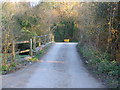
1
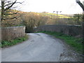
Bridge on Stoneage Lane
A view looking south towards the bridge over the old railway trackbed on Stoneage Lane. The railway was the Limpley Stoke to Camerton branch of the Great Western Railway, which closed in 1951 as a result of the closure of Camerton Colliery in 1950. The branch was used in 1952 in the making of the film “The Titfield Thunderbolt”.
Image: © Phil Williams
Taken: 13 Mar 2007
0.05 miles
2
Old railway trackbed
A view looking east from the parapet of the bridge on stonewage Lane, along the course of the old trackbed of Great Western Railway (GWR) Limpley Stoke to Camerton branch line. The branch closed in 1951 as a result of the closure of Camerton Colliery in 1950, but was used in 1952 in the making of the film “The Titfield Thunderbolt”.
Image: © Phil Williams
Taken: 13 Mar 2007
0.05 miles
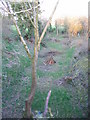
3
Footpath alongside the Cam Brook
A view looking to the east across Stoneage Lane towards the entrance to a public footpath alongside the Cam Brook (on the right). This footpath forms part of the route of the Limestone Link http://www.walkingontheweb.co.uk/Defined%20Routes/Limestone%20Link%20Path.htm between the West Mendip Way and the Cotswold Way.
Image: © Phil Williams
Taken: 13 Mar 2007
0.07 miles
4
Waterlogged meadow
A view looking south from Stoneage Lane across a waterlogged meadow, towards the Wessex Water pumping station on the south bank of the Cam Brook.
Image: © Phil Williams
Taken: 13 Mar 2007
0.07 miles
5
Bridge over the Cam Brook
A view looking to the southeast along Stoneage Lane showing the single track bridge over the Cam Brook.
Image: © Phil Williams
Taken: 13 Mar 2007
0.07 miles
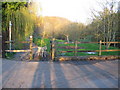
6
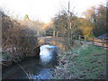
Bridge over the Cam Brook
A view looking to the northeast towards the single track bridge over the Cam Brook.
Image: © Phil Williams
Taken: 13 Mar 2007
0.08 miles
7

The Cam Brook
A view looking to the east, downstream along the Cam Brook, from the single track bridge on Stoneage Lane.
Image: © Phil Williams
Taken: 13 Mar 2007
0.08 miles
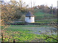
8
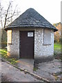
Wessex Water pumping station
A view looking to the west towards the building of the Wessex Water pumping station alongside the Cam Brook off Stoneage Lane.
Image: © Phil Williams
Taken: 13 Mar 2007
0.09 miles
9
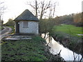
The Cam Brook
A view looking west along the Cam Brook showing the building of the Wessex Water pumping station on the south bank.
Image: © Phil Williams
Taken: 13 Mar 2007
0.10 miles
10
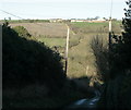
2009 : Stoneage Lane north from Carlingcott
Down a steep an slippery hill to the Cam Brook and Stoneage Farm then up an equally steep but not so slippery hill to Tunley sitting on the top.
Image: © Maurice Pullin
Taken: 20 Dec 2009
0.20 miles