IMAGES TAKEN NEAR TO
Church Road, BATH, BA2 8AE
Introduction
This page details the photographs taken nearby to Church Road, BA2 8AE by members of the Geograph project.
The Geograph project started in 2005 with the aim of publishing, organising and preserving representative images for every square kilometre of Great Britain, Ireland and the Isle of Man.

There are currently over 7.5m images from over14,400 individuals and you can help contribute to the project by visiting https://www.geograph.org.uk
Image Map
Images are licensed for reuse under creativecommons.org/licenses/by-sa/2.0
Notes
- Clicking on the map will re-center to the selected point.
- The higher the marker number, the further away the image location is from the centre of the postcode.
Image Listing (7 Images Found)
Images are licensed for reuse under creativecommons.org/licenses/by-sa/2.0
Image
Details
Distance
1

Unsuitable for wide users
A footpath/road has some conflicts of restriction.
Image: © Neil Owen
Taken: 24 May 2022
0.04 miles
2
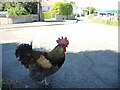
It's an old question
The chicken was one of several that were roaming free on the quiet roads hereabouts, calmly and serenely exploring for morsels. There was a moment to pose the obvious; he stopped for a short pause but said he had other plots to hatch.
Image: © Neil Owen
Taken: 24 May 2022
0.07 miles
3

St John the Baptist
Church at Peasdown St John.
Image: © Wayland Smith
Taken: 2 Apr 2021
0.12 miles
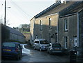
4

St John's hall
Next to the church is a metal-clad hall. It stands where the original church stood in the past.
Image: © Neil Owen
Taken: 24 May 2022
0.14 miles
5
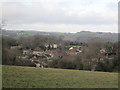
New Buildings Peasedown St John
A view from the recreation ground looking down over the hamlet of New Buildings
Image: © Michael Claydon
Taken: 9 Jan 2014
0.18 miles
6
2009 : Carlingcott the south west corner
The icy lane heads south for Peasedown.
Image: © Maurice Pullin
Taken: 20 Dec 2009
0.24 miles
7
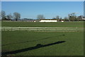
Recreation Ground, Peasedown St John
The Miners Welfare Recreation Ground, seen here from the Fosse Way / Bath Road.
Image: © Derek Harper
Taken: 24 Feb 2016
0.25 miles