IMAGES TAKEN NEAR TO
Woolverton, BATH, BA2 7RG
Introduction
This page details the photographs taken nearby to BA2 7RG by members of the Geograph project.
The Geograph project started in 2005 with the aim of publishing, organising and preserving representative images for every square kilometre of Great Britain, Ireland and the Isle of Man.

There are currently over 7.5m images from over14,400 individuals and you can help contribute to the project by visiting https://www.geograph.org.uk
Image Map
Images are licensed for reuse under creativecommons.org/licenses/by-sa/2.0
Notes
- Clicking on the map will re-center to the selected point.
- The higher the marker number, the further away the image location is from the centre of the postcode.
Image Listing (17 Images Found)
Images are licensed for reuse under creativecommons.org/licenses/by-sa/2.0
Image
Details
Distance
1
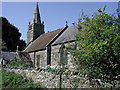
Woolverton (Somerset) Former Church
The medieval church of St Lawrence has been converted into a private house. This picture was taken when work was well in hand.
Image: © ChurchCrawler
Taken: 14 Aug 2003
0.14 miles
2
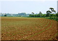
2008 : Maize field near Woolverton
Taken on 24th May, the plants have been growing for about a week. By the end of September they will be above head high. This was the stuff that was "high as an elephant's eye" in Oklahoma. Must have been a small elephant.
Image: © Maurice Pullin
Taken: 24 May 2008
0.14 miles
5
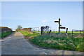
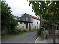
Crossroads by Sleight Farm
The signpost has suffered a bit with one arm broken off and another with what looks like a wooden or sheet substitute for the original cast-iron. Woolverton straight on, Frome right, Lullington behind, and left is currently unknown.
Image: © Robin Webster
Taken: 2 Mar 2017
0.17 miles
6
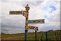
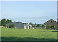
Direction Sign - Signpost near Sleight Farm south of Woolverton
Pyramid finial - 4 arms; Somerset SCC pyramid by the UC road, in parish of Tellisford (Mendip District), south of Woolverton on the northeast side of the crossroads near Sleight Farm.
surveyed
Milestone Society National ID: SO_ST7953
Image: © Milestone Society
Taken: Unknown
0.17 miles
8
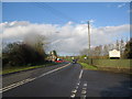
A36 at Woolverton
A view looking north along the A36 towards the junction of the B3110 at Woolverton.
Image: © Phil Williams
Taken: 26 Nov 2006
0.18 miles
9
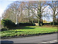
War Memorial at Woolverton
A view looking west across the A36 towards the war memorial at Woolverton.
Image: © Phil Williams
Taken: 26 Nov 2006
0.18 miles
