IMAGES TAKEN NEAR TO
Norton St. Philip, BATH, BA2 7NN
Introduction
This page details the photographs taken nearby to BA2 7NN by members of the Geograph project.
The Geograph project started in 2005 with the aim of publishing, organising and preserving representative images for every square kilometre of Great Britain, Ireland and the Isle of Man.

There are currently over 7.5m images from over14,400 individuals and you can help contribute to the project by visiting https://www.geograph.org.uk
Image Map
Images are licensed for reuse under creativecommons.org/licenses/by-sa/2.0
Notes
- Clicking on the map will re-center to the selected point.
- The higher the marker number, the further away the image location is from the centre of the postcode.
Image Listing (4 Images Found)
Images are licensed for reuse under creativecommons.org/licenses/by-sa/2.0
Image
Details
Distance
1
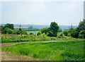
2008 :Corner of a wheat field near Peart Farm
Nothing in this direction, south west, apart from good farm land until you come to Evercreech. Farms, hamlets and a small village or two. Evercreech is not very big either.
Image: © Maurice Pullin
Taken: 24 May 2008
0.05 miles
2
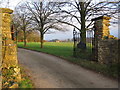
Gates to Peart Farm
A view looking to the east through the gates at the entrance to Peart Farm.
Image: © Phil Williams
Taken: 31 Jan 2007
0.10 miles
3
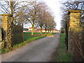
Peart Farm
A view looking to the northeast through the gates of the access lane to Peart Farm.
Image: © Phil Williams
Taken: 31 Jan 2007
0.16 miles
4
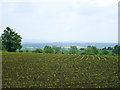
2008 : Maize field near Norton St. Philip
Almost the last week in May and the newly sprung plants are almost insignificant, by September they will be more than head high for most of us and we could get lost in there.
Image: © Maurice Pullin
Taken: 24 May 2008
0.17 miles