IMAGES TAKEN NEAR TO
Tellisford Lane, BATH, BA2 7LL
Introduction
This page details the photographs taken nearby to Tellisford Lane, BA2 7LL by members of the Geograph project.
The Geograph project started in 2005 with the aim of publishing, organising and preserving representative images for every square kilometre of Great Britain, Ireland and the Isle of Man.

There are currently over 7.5m images from over14,400 individuals and you can help contribute to the project by visiting https://www.geograph.org.uk
Image Map
Images are licensed for reuse under creativecommons.org/licenses/by-sa/2.0
Notes
- Clicking on the map will re-center to the selected point.
- The higher the marker number, the further away the image location is from the centre of the postcode.
Image Listing (18 Images Found)
Images are licensed for reuse under creativecommons.org/licenses/by-sa/2.0
Image
Details
Distance
1
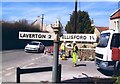
Direction Sign - Signpost on the B3110 Frome Road, Norton St Philip
Pyramid finial - 2 arms; Somerset SCC pyramid by the B3110, in parish of Norton St Philip (Mendip District), on the east side of the crossroads of the B3110 Frome Road, Tellisford Lane and Mackley Lane.
surveyed
Milestone Society National ID: SO_ST7755A
Image: © Milestone Society
Taken: Unknown
0.08 miles
2

Golden crop
Some hay bales drying in the October sunshine.
Image: © Neil Owen
Taken: 12 Oct 2016
0.08 miles
3
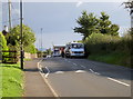
Calming down
This stretch of the Frome Road used to have chicanes to 'calm' the traffic. A couple of years ago they were removed and these speed humps put in their place. Traffic today needs no more calming, what with the breakdown truck in attendance.
Image: © Neil Owen
Taken: 12 Oct 2016
0.09 miles
4

To Peart Farm
A path across the fields to a farm some half a mile away.
Image: © Neil Owen
Taken: 12 Oct 2016
0.12 miles
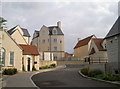
5

A range of styles
This is the new development of Fortescue Fields in Norton St Philip. It occupies a site that used to be a chicken processing plant in the latter twentieth century, but has been transformed into a modern and distinctive range of homes and small retail units.
The estate was designed by acclaimed architect Robert Adam and blends Georgian influences with modern materials and features. This is part of the result - no long rows of identical houses or economic constraints here!
Image: © Neil Owen
Taken: 12 Oct 2016
0.15 miles
6

For public use
Robert Adam's striking design of Fortescue Fields allowed for a building that the community could use, rather in the vein of a village hall. Its blended style of Georgian and rustic includes the provision of lots of local materials to keep it in sympathy. Despite many objections and planning delays, this new estate has won many admirers.
Image: © Neil Owen
Taken: 12 Oct 2016
0.16 miles
7

Fortescue Fields
This very stylish new development in Norton St Philip catches the eye for its warm stone colouring and unusual asymmetry.
Image: © Neil Owen
Taken: 12 Oct 2016
0.16 miles
8

To Foxholes Lane
A footpath runs across the fields to the east of Norton Saint Philip and past the new housing development. Some official notices warn of impending alterations.
Image: © Neil Owen
Taken: 12 Oct 2016
0.17 miles
9
Somerset style
The design of Fortescue Fields by Robert Adam comes as something of a surprise in the small and largely rustic village of Norton St Philip. Taking local materials and blending them with Georgian influences, and ensuring that nothing looks similar to one another, the result is a skyline that stands out.
Image: © Neil Owen
Taken: 12 Oct 2016
0.19 miles
10
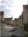
Not one the same as another
The new development of Fortescue Fields was designed with about fifty homes, some assisted, all of which are unique in appearance. You would not believe this was the site of a chicken factory.
Image: © Neil Owen
Taken: 12 Oct 2016
0.19 miles