IMAGES TAKEN NEAR TO
Lower Stoke, BATH, BA2 7FJ
Introduction
This page details the photographs taken nearby to Lower Stoke, BA2 7FJ by members of the Geograph project.
The Geograph project started in 2005 with the aim of publishing, organising and preserving representative images for every square kilometre of Great Britain, Ireland and the Isle of Man.

There are currently over 7.5m images from over14,400 individuals and you can help contribute to the project by visiting https://www.geograph.org.uk
Image Map
Images are licensed for reuse under creativecommons.org/licenses/by-sa/2.0
Notes
- Clicking on the map will re-center to the selected point.
- The higher the marker number, the further away the image location is from the centre of the postcode.
Image Listing (77 Images Found)
Images are licensed for reuse under creativecommons.org/licenses/by-sa/2.0
Image
Details
Distance
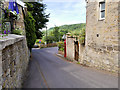
2
Former Station at Limpley Stoke
The station served as a loading point for limestone from nearby quarries until 1960.
Image: © David Dixon
Taken: 19 Jun 2017
0.04 miles
3
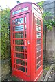
Limpley Stoke : Telephone Box
A telephone box used now as a book box and dedicated to HM Queen Elizabeth II.
Image: © Lewis Clarke
Taken: 18 Oct 2022
0.04 miles
4
Station Garage, Limpley Stoke
Limpley Stoke railway station is no longer there, but it is commemorated by the name of this garage, with its rather old-fashioned frontage and lettering style.
Image: © HelenK
Taken: 28 Feb 2014
0.04 miles
5

Limpley Stoke : Crowe Hill
Crowe Hill with Station Garage in view.
Image: © Lewis Clarke
Taken: 18 Oct 2022
0.05 miles
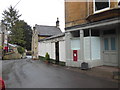
6

2007 : Limpley Stoke Post Office
Recently closed, the premises are for sale.
Image: © Maurice Pullin
Taken: 21 Oct 2007
0.05 miles
7

Limpley Stoke : Hop Pole Inn
The Hop Pole sadly closed its doors a few years ago. There is a campaign to save the building https://www.limpleystokecbs.org/.
Image: © Lewis Clarke
Taken: 18 Oct 2022
0.05 miles
8
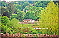
Former Limpley Stoke station, from across Avon Valley
View westward, the railway being the ex-GWR Bath (to right) - (to left) Westbury secondary main line. In spite of appearances, the station was closed from 3/10/66: it has been restored, as a restaurant.
Image: © Ben Brooksbank
Taken: 15 May 2001
0.05 miles
9
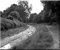
Kennet and Avon Canal, Limpley Stoke: canal bed under repair
The canal bed along this stretch had been notoriously prone to water loss by seepage, so when the canal was being restored he opportunity was taken to put in a plastic liner. The photograph shows the canal as prepared for this to be put in.
Image: © Dr Neil Clifton
Taken: 25 Sep 1977
0.05 miles
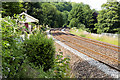
10
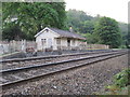
Limpley Stoke railway station site, Wiltshire
Opened in 1857 by the Great Western Railway on its line from Bath to Westbury, this station closed in 1966. View north towards Bathampton and Bath.
Image: © Nigel Thompson
Taken: 28 Apr 2011
0.05 miles