IMAGES TAKEN NEAR TO
Old Midford Road, BATH, BA2 7DH
Introduction
This page details the photographs taken nearby to Old Midford Road, BA2 7DH by members of the Geograph project.
The Geograph project started in 2005 with the aim of publishing, organising and preserving representative images for every square kilometre of Great Britain, Ireland and the Isle of Man.

There are currently over 7.5m images from over14,400 individuals and you can help contribute to the project by visiting https://www.geograph.org.uk
Image Map
Images are licensed for reuse under creativecommons.org/licenses/by-sa/2.0
Notes
- Clicking on the map will re-center to the selected point.
- The higher the marker number, the further away the image location is from the centre of the postcode.
Image Listing (9 Images Found)
Images are licensed for reuse under creativecommons.org/licenses/by-sa/2.0
Image
Details
Distance
1
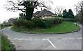
Old Midford Road, near Midford
The viewpoint is the Old Midford Road as is the road leading away from the viewpoint at the right. The road to the left leads to the village of Southstoke.
Image: © Brian Robert Marshall
Taken: 3 Jan 2008
0.02 miles
2

Footpath near Southstoke
The footpath crosses small fields from one minor road to another.
Image: © Maigheach-gheal
Taken: 20 Sep 2009
0.08 miles
3

Old Milepost by the B3110, Midford Road, South Stoke parish
Cast iron post by the B3110, in parish of SOUTH STOKE (BATH AND NORTH EAST SOMERSET District), Midford Road, between Key Inn at Combe Down and Midford, in dark hedge beside road, on South side of road. C&M Classical iron casting, erected by the Black Dog turnpike trust in the 19th century.
Inscription reads:-
BATH
3
WARMINSTER
14
FROME
10
Grade II listed.
List Entry Number: 1277078 https://historicengland.org.uk/listing/the-list/list-entry/1277078
Milestone Society National ID: SO_BAWM03.
Image: © JR Dowding
Taken: 4 Aug 2007
0.08 miles
4
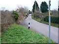
Old Midford Road, near Midford
The Old Midford Road terminates about 500 metres from the viewpoint near the southern gridline at a very awkward junction with the B3110. Not recommended.
Image: © Brian Robert Marshall
Taken: 3 Jan 2008
0.09 miles
5

2008 : Pasture near Southstoke
The uncropped clumps of grass in this field suggests it was used for horses,
Image: © Maurice Pullin
Taken: 27 Apr 2008
0.15 miles
6

The B3110 heading towards Midford
The housing continues a little longer on this side of the road, before one reaches the limits of this part of Bath.
Image: © HelenK
Taken: 27 Jun 2013
0.19 miles
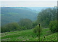
7
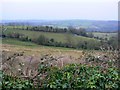
A view south-west from the Old Midford Road, near Midford and South Stoke
Taken on a rather bleak day, it is easy to imagine that the view in summer would be quite spectacular.
Image: © Brian Robert Marshall
Taken: 3 Jan 2008
0.20 miles
8
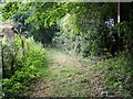
Footpath near Southstoke
The footpath takes walkers to Upper Midford.
Image: © Maigheach-gheal
Taken: 20 Sep 2009
0.22 miles
9
2008 : Bottom end of Horsecombe Vale
A pleasant little valley, well worth the effort of a walk along the bottom beside the little stream.
Image: © Maurice Pullin
Taken: 27 Apr 2008
0.24 miles