IMAGES TAKEN NEAR TO
Beldon Crescent, BATH, BA2 6DP
Introduction
This page details the photographs taken nearby to Beldon Crescent, BA2 6DP by members of the Geograph project.
The Geograph project started in 2005 with the aim of publishing, organising and preserving representative images for every square kilometre of Great Britain, Ireland and the Isle of Man.

There are currently over 7.5m images from over14,400 individuals and you can help contribute to the project by visiting https://www.geograph.org.uk
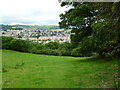
Image Map
Images are licensed for reuse under creativecommons.org/licenses/by-sa/2.0
Notes
- Clicking on the map will re-center to the selected point.
- The higher the marker number, the further away the image location is from the centre of the postcode.
Image Listing (79 Images Found)
Images are licensed for reuse under creativecommons.org/licenses/by-sa/2.0
Image
Details
Distance
1

Bathampton, Warminster Road
Descending into Bath from Bathampton; an exit from MoD buildings on the right.
Image: © Mike Faherty
Taken: 18 Jul 2011
0.01 miles
2

Grazing pasture beside the Kennet & Avon canal
Sheep graze peacefully in this meadow behind the Government Administrative Buildings in the A36 Warminster Road, a striking contrast to the barbed wire topped fencing at the front of this site.
Image: © Dr Duncan Pepper
Taken: 30 May 2009
0.05 miles

4

Cruising East
Cruising east along the Kennet & Avon Canal at Bath, viewed through flora growing along the towpath.
Image: © David Roberts
Taken: 21 Aug 2009
0.08 miles
5

2008 : Welcome to Bath
On the A36 from Warminster.
One of the few places within a mile of the centre of Bath where you can park your car, most other spots are for residents only.
One would think a World Heritage Site would take better care of its sign.
Image: © Maurice Pullin
Taken: 4 Aug 2008
0.08 miles
6
Bathampton, footpath
From Warminster Road at the city boundary down to Grosvenor Bridge, with good views of the city in the distance.
Image: © Mike Faherty
Taken: 18 Jul 2011
0.09 miles
7

Old Boundary Marker by the A36, Warminster Road, Bathampton
County Boundary Marker by the A36, in parish of Bathampton (Bath and North East Somerset District), Warminster Road, near top of hill, next to footpath entrance, against wall.
Inscription reads:-
: CITY OF BATH : : BOUNDARY / 1912 : : SOMERSET CC :
Surveyed
Milestone Society National ID: SO_SSBA02cb
Image: © Milestone Society
Taken: Unknown
0.09 miles
8
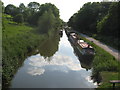
The Kennet & Avon Canal
Looking SW from the footbridge to Hampton Hall
Image: © Dr Duncan Pepper
Taken: 30 May 2009
0.09 miles
9

Kennet & Avon Canal, between bridges 185 and 186
Popular with walkers as well as boaters.
Image: © Christine Johnstone
Taken: 2 May 2015
0.10 miles
10
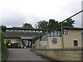
Bathwick St. Mary primary school
This Church of England voluntary aided primary school was founded in 1845 and moved to its present site in 1986.
Image: © HelenK
Taken: 21 Jun 2007
0.10 miles