IMAGES TAKEN NEAR TO
Prospect Road, BATH, BA2 6AY
Introduction
This page details the photographs taken nearby to Prospect Road, BA2 6AY by members of the Geograph project.
The Geograph project started in 2005 with the aim of publishing, organising and preserving representative images for every square kilometre of Great Britain, Ireland and the Isle of Man.

There are currently over 7.5m images from over14,400 individuals and you can help contribute to the project by visiting https://www.geograph.org.uk
Image Map
Images are licensed for reuse under creativecommons.org/licenses/by-sa/2.0
Notes
- Clicking on the map will re-center to the selected point.
- The higher the marker number, the further away the image location is from the centre of the postcode.
Image Listing (24 Images Found)
Images are licensed for reuse under creativecommons.org/licenses/by-sa/2.0
Image
Details
Distance
1
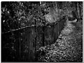
Track from Widcombe Hill Bath
Part of the 6 mile National Trust's Bath Skyline Walk. According to the Trust web site it is their most popular walk ( there are over 170 listed)
A uphill track bounded by railings and a hedge.
Image: © Gillie Rhodes
Taken: 18 Feb 2011
0.04 miles
2
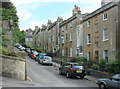
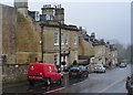
2008 : Macauley Buildings, Bath
One envies the fine views from the backs of these houses.
Image: © Maurice Pullin
Taken: 24 Jul 2008
0.04 miles
3
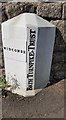
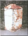
Old Boundary Marker on Widcombe Hill, Bath
Turnpike Parish Boundary Marker on the pavement against a wall on the north side of Widcombe Hill, Bath, Opposite Macaulay Buildings. In raised lettering WIDCOMBE on the left and BATH TURNPIKE TRUST vertically up the front. The parish name BATHWICK on the right and the normal date at the top are missing. Grade II Listed details https://historicengland.org.uk/listing/the-list/list-entry/1395760. Repainted since the 2008 photo https://www.geograph.org.uk/photo/6072517. See also https://www.geograph.org.uk/photo/5252390.
Milestone Society National ID: SO_BACLpb
Image: © A Newton
Taken: 1 Sep 2020
0.09 miles
4
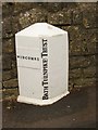
Widcombe - Road Marker
Bath Turnpike Trust pillar at Widcombe Hill on the outskirts of Bath.
Image: © Colin Smith
Taken: 28 Mar 2015
0.09 miles
5
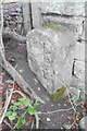
Old Boundary Marker on Widcombe Hill, Bath
Parish Boundary Marker - Turnpike by the UC road, in parish of Bath (Bath And North East Somerset District), Widcombe Hill, Bath, on pavement against wall, North side of road, opposite Macauley Buildings (road).
Inscription reads:-
: WIDCOMBE : : BATH TURNPIKE TRUST :
Grade II listed.
List Entry Number: 1395760 https://historicengland.org.uk/listing/the-list/list-entry/1395760
Surveyed
Milestone Society National ID: SO_BACLpb
Image: © Milestone Society
Taken: Unknown
0.10 miles
6
Bath - Widcombe Hill
A red Post Office van brightens up a wet scene on the "Skyline Walk".
Image: © Colin Smith
Taken: 28 Mar 2015
0.11 miles
7
Old Boundary Marker south of Widcombe Hill, Bath
Boundary Marker where a stone wall meets a fence in the middle of a wood south of Widcombe Hill, a road. Not marked on OS maps until 1904. On the former boundary of Bathwick and Claverton parishes, from 1900 Bath and Claverton parishes, from 1951 entirely in Bath parish. The inscription E B / V W does not relate to any of these.
Milestone Society National ID: SO_BATH05bm
Image: © A Ward
Taken: 28 Nov 2021
0.13 miles
8
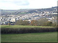
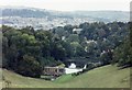
City and countryside
This view from Widcombe Hill shows how Bath is very close to open countryside. The Abbey can be seen to the left and directly above the walker is part of the Royal Crescent.
Image: © Jonathan Billinger
Taken: 29 Nov 2007
0.15 miles
9
Prior Park Landscape Garden, Bath
Property of the National Trust. The view down the valley shows the Palladian Bridge (18th century) and the lakes beyond.
Image: © David Smith
Taken: Unknown
0.15 miles
10
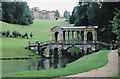
Prior Park
A National Trust property.
Image: © Roger Cornfoot
Taken: 30 Dec 2006
0.15 miles