IMAGES TAKEN NEAR TO
Stonehouse Close, BATH, BA2 5DP
Introduction
This page details the photographs taken nearby to Stonehouse Close, BA2 5DP by members of the Geograph project.
The Geograph project started in 2005 with the aim of publishing, organising and preserving representative images for every square kilometre of Great Britain, Ireland and the Isle of Man.

There are currently over 7.5m images from over14,400 individuals and you can help contribute to the project by visiting https://www.geograph.org.uk
Image Map
Images are licensed for reuse under creativecommons.org/licenses/by-sa/2.0
Notes
- Clicking on the map will re-center to the selected point.
- The higher the marker number, the further away the image location is from the centre of the postcode.
Image Listing (25 Images Found)
Images are licensed for reuse under creativecommons.org/licenses/by-sa/2.0
Image
Details
Distance
2

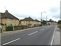
Old Boundary Marker by the A3062, Bradford Road, Combe Down
County Boundary Marker by the A3062, in parish of Southstoke (Bath And North East Somerset District), Bradford Road, next to wall at junction with Combe Road opposite.
Inscription reads:- : CITY OF BATH : : (SO)MERSET C.C. : : BOUNDARY / 1912 :
Surveyed
Milestone Society National ID: SO_SSBA03cb.
Image: © Milestone Society
Taken: Unknown
0.09 miles
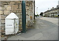
3

Old Boundary Marker by the A3062, Bradford Road, Bath
Parish Boundary Marker - Turnpike by the A3062, in parish of Bath (Bath and North East Somerset District), junction of Bradford Road with Combe Road, on pavement against stone wall of No. 190.
Inscription reads:-
: COMBE : : 1827 / (BAT)H TURNPIKE TRUST : : WIDCOMBE :
Grade II listed.
List Entry Number: 1394949 https://historicengland.org.uk/listing/the-list/list-entry/1394949
Surveyed
Milestone Society National ID: SO_BARA01pb
Image: © Milestone Society
Taken: Unknown
0.10 miles
4
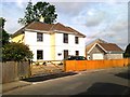
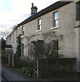
Combe Down, North Road
Faced in, presumably, local stone.
Image: © Mike Faherty
Taken: 18 Jul 2011
0.10 miles
5
Turnpike trust boundary stone, Bradford Road, Combe Down
Image: © Humphrey Bolton
Taken: 19 Sep 2013
0.10 miles

7
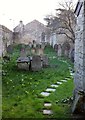
Jewish Burial Ground, Combe Down
The view to the left of Image], with the wall of the ohel (which dates originally from 1836) on the immediate right. "This is one of only fifteen cemeteries surviving from the Georgian period in the country. The cemetery is notable for the survival of its Ohel(chapel) and the presence of two chest tombs. Despite a prolonged period of neglect since the closure of the cemetery in the early C20, the (approximately) fifty tombstones, walls, gate and Ohel remain essentially intact and the cemetery survives as an important reminder of one of the smaller social minority groups within Bath society" https://historicengland.org.uk/listing/the-list/list-entry/1396344 . Beyond the cemetery is Greendown House, dating from 1806 https://www.historicengland.org.uk/listing/the-list/list-entry/1394946 .
Image: © Derek Harper
Taken: 23 Feb 2016
0.15 miles
8
Listed buildings, Combe Down
Bearer is 24, Combe Road https://www.historicengland.org.uk/listing/the-list/list-entry/1394950 ; beyond is a row of three "artisanal houses, probably related to the quarrying industry for which Combe Down was celebrated at this time" https://www.historicengland.org.uk/listing/the-list/list-entry/1394952 .
Image: © Derek Harper
Taken: 23 Feb 2016
0.15 miles
9

The Forester and Flower, Combe Down
Inn with accommodation on the edge of Bath
Image: © David Smith
Taken: 26 Nov 2016
0.16 miles
10
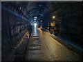
Bath : Combe Down Tunnel
On the footpath heading through Combe Down Tunnel. A cyclist approaches out of the darkness. Opened in 1874, this 1,829-yard (1,672 m) long disused railway tunnel was once the UK’s longest without intermediate ventilation. The tunnel now forms part of the £1.8 million Two Tunnels Greenway walking and cycling path opened on 6 April 2013 and is the longest cycling tunnel in Britain.
Image: © Lewis Clarke
Taken: 6 Aug 2020
0.16 miles