IMAGES TAKEN NEAR TO
Kipling Avenue, BATH, BA2 4RE
Introduction
This page details the photographs taken nearby to Kipling Avenue, BA2 4RE by members of the Geograph project.
The Geograph project started in 2005 with the aim of publishing, organising and preserving representative images for every square kilometre of Great Britain, Ireland and the Isle of Man.

There are currently over 7.5m images from over14,400 individuals and you can help contribute to the project by visiting https://www.geograph.org.uk
Image Map
Images are licensed for reuse under creativecommons.org/licenses/by-sa/2.0
Notes
- Clicking on the map will re-center to the selected point.
- The higher the marker number, the further away the image location is from the centre of the postcode.
Image Listing (58 Images Found)
Images are licensed for reuse under creativecommons.org/licenses/by-sa/2.0
Image
Details
Distance
1
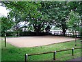
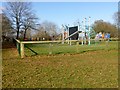
Boules pitch, Alexandra Park
Court or piste for the game of boules or pétanque, which seems to be quite popular in this part of the country.
Roofs behind the fence are at Beechen Cliff School.
Image: © Rose and Trev Clough
Taken: 10 Jul 2012
0.05 miles
2
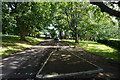
Ring road in Alexandra Park
The road loops right round the park, giving an opportunity for parking along it. Much of the park is pleasantly shady.
Image: © Bill Boaden
Taken: 29 Jul 2016
0.07 miles
3
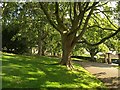
Alexandra Park, Bath
A view on the western side of the hilltop park, close to where the road enters from Shakespeare Avenue.
Image: © Derek Harper
Taken: 25 Aug 2008
0.08 miles
4

Entrance to Alexandra Park from Shakespeare Avenue
There is a circular drive around the park, where car parking is permitted - much appreciated by those of us with limited mobility.
Alexandra Park is on the top of Beechen Cliff, giving magnificent views across the city of Bath.
For more information, see the park's website http://alexandraparkbath.org/ .
Image: © Rose and Trev Clough
Taken: 10 Jul 2012
0.10 miles
5

Park gates in Alexandra Park
These are the gates at the head of Shakespeare Avenue, which is the main entrance.
Image: © Bill Boaden
Taken: 29 Jul 2016
0.10 miles
7

Colourful flower border, Alexandra Park
Mixed annuals growing near Image .
The seeds were sown by people from the local community, who are actively involved in the management of this park - see website http://alexandraparkbath.org/ .
Image: © Rose and Trev Clough
Taken: 10 Jul 2012
0.11 miles
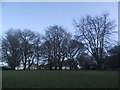
8
Lyncombe Hill
Parked on road near entrance to Alexandra Park then I had a walk up to and across the play area.
Name: Lyncombe Hill
Hill number: 18243
Height: 127m / 417ft
Parent (Ma/M): 2891 Beacon Batch
Section: 41: South Central England
County/UA: Bath and NE Somerset (CoU)
Class: Tump (100-199m)
Grid ref: ST 75131 63917
Summit feature: no feature: ground near roundabout in playground
Drop: 33m
Col: 94m ST746633
Image: © Rude Health
Taken: 26 Mar 2015
0.12 miles
9
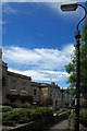
Shakespeare Avenue, Bath
Image: © Derek Harper
Taken: 25 Aug 2008
0.13 miles
10
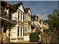
Public footpath past front gardens, Bath
Image: © Simon Barnes
Taken: 2 Jun 2007
0.13 miles