IMAGES TAKEN NEAR TO
Calton Walk, BATH, BA2 4QQ
Introduction
This page details the photographs taken nearby to Calton Walk, BA2 4QQ by members of the Geograph project.
The Geograph project started in 2005 with the aim of publishing, organising and preserving representative images for every square kilometre of Great Britain, Ireland and the Isle of Man.

There are currently over 7.5m images from over14,400 individuals and you can help contribute to the project by visiting https://www.geograph.org.uk
Image Map
Images are licensed for reuse under creativecommons.org/licenses/by-sa/2.0
Notes
- Clicking on the map will re-center to the selected point.
- The higher the marker number, the further away the image location is from the centre of the postcode.
Image Listing (391 Images Found)
Images are licensed for reuse under creativecommons.org/licenses/by-sa/2.0
Image
Details
Distance

2

Junction of Wells Road and Claverton Street
Claverton Street is the main road running across this photo, with Wells Road in the foreground. A railway viaduct in the middle distance with a train heading for Bristol. The spire in the distance is St John's Catholic church in the city centre Image
Image: © Stephen Craven
Taken: 22 Nov 1998
0.07 miles
3

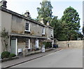
Calton Gardens and Calton Walk
Calton Walk leads down towards Holloway and the railway station area.
Image: © Roger Templeman
Taken: 3 Sep 2010
0.07 miles
4
Grade II Listed houses at the western end of St Mark's Road, Widcombe, Bath
The houses built c1830 were Grade II Listed in 1975.
Image: © Jaggery
Taken: 3 Sep 2018
0.07 miles
5
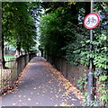
Wall at the western end of St Mark's Road, Widcombe, Bath
Out of shot ahead, a path https://www.geograph.org.uk/photo/5980223 heads west towards the Oldfield Park area of Bath.
Image: © Jaggery
Taken: 3 Sep 2018
0.07 miles
6
Wells Road
Railway Line at Wells Road, Bath.
Image: © Wayland Smith
Taken: 26 Mar 2017
0.07 miles
7
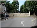
No cycling on a footpath west of St Mark's Road, Widcombe, Bath
In 2018, many paths in the UK are combined footpaths and cycleways.
The sign shows that this path west towards the Oldfield Park area of Bath is for walkers only.
Image: © Jaggery
Taken: 3 Sep 2018
0.07 miles
8
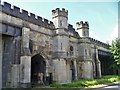
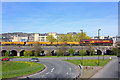
St James' Viaduct
Opened in 1840, the entire viaduct consists of 17 arches plus roadway arches and pedestrian arches. The southern central Tudor Gothic section is seen here. Listed, grade II*, there is much detail and histoty at: https://www.historicengland.org.uk/listing/the-list/list-entry/1395115
Image: © Michael Dibb
Taken: 2 Jun 2018
0.08 miles
9
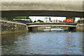
Churchill Road Bridge, River Avon, Bath
Viewed from under Southgate Bridge, looking downstream.
Image: © Pierre Terre
Taken: 20 May 2006
0.08 miles
10

Widcombe Acorns entrance door, St Mark's Road, Bath
The green door at the entrance to the preschool playgroup is here. https://www.geograph.org.uk/photo/5980248
Image: © Jaggery
Taken: 3 Sep 2018
0.08 miles