IMAGES TAKEN NEAR TO
Georges Place, BATH, BA2 4EN
Introduction
This page details the photographs taken nearby to Georges Place, BA2 4EN by members of the Geograph project.
The Geograph project started in 2005 with the aim of publishing, organising and preserving representative images for every square kilometre of Great Britain, Ireland and the Isle of Man.

There are currently over 7.5m images from over14,400 individuals and you can help contribute to the project by visiting https://www.geograph.org.uk
Image Map
Images are licensed for reuse under creativecommons.org/licenses/by-sa/2.0
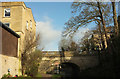
Notes
- Clicking on the map will re-center to the selected point.
- The higher the marker number, the further away the image location is from the centre of the postcode.
Image Listing (303 Images Found)
Images are licensed for reuse under creativecommons.org/licenses/by-sa/2.0
Image
Details
Distance
1
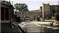
Pulteney Bridge
This photograph of the Pulteney Bridge was taken from the northern end of Parade Gardens on the western bank of the River Avon
Pulteney Bridge was commissioned by Frances Pulteney and designed by Robert Adam.
For more information see the Building History web page: http://www.buildinghistory.org/bath/georgian/pulteney-bridge.shtml.
- - -
See also these photographs by:
John Myers: Image (1987),
Tom Pennington: Image (1996),
Martyn Pattison: Image (2005),
Mike Alexander: Image (2006),
Mr M Evison: Image (2007),
Alan Morrison: Image (2008),
Paul Bolland: Image (2008) and
Julian P Guffogg: Image (2009).
- - -
This is a scanned image of a 35mm slide taken during the summer of 1974.
Image: © Alan Walker
Taken: Unknown
0.02 miles
2
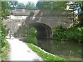
Bridging the canal
The bridge, built circa 1810, carries Bathwick Hill over the Kennet & Avon Canal. Listed, grade II, with details at: https://www.historicengland.org.uk/listing/the-list/list-entry/1394244
Image: © Michael Dibb
Taken: 2 Jun 2018
0.02 miles
3
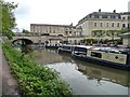
Sydney Wharf and Sydney Wharf Bridge, Bath
The wharf is home to a boat hire business.
Image: © Christine Johnstone
Taken: 2 May 2015
0.02 miles
4
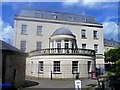
The Moorings
Built in 1998, The Moorings comprises 54 retirement apartments. Seen from the bridge carrying Bathwick Hill over the Kennet & Avon Canal.
Image: © Michael Dibb
Taken: 2 Jun 2018
0.02 miles
5
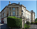
Bathwick Terrace, Bathwick Hill, Bath
An aborted project but what exists is a terrace of three houses putting on a bit of a show to the street with giant Ionic columns and pediment. Probably by John Pinch the Elder, c1825. Grade II listed.
Image: © Stephen Richards
Taken: 25 May 2012
0.02 miles
6
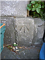
Benchmark on 1 Bathwick Terrace
Tucked away behind some recycling boxes is a benchmark, one of many running up the steep Bathwick Hill. See Image] for a view of the building it's on, and http://www.bench-marks.org.uk/bm39455 for the Benchmark Database. Apologies for the shaky shot...
Image: © Neil Owen
Taken: 2 Sep 2011
0.02 miles
7
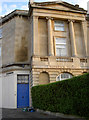
Number 1, Bathwick Terrace
The actual terrace is pretty short and a cul-de-sac; the main road runs up the hill. A benchmark can be found close to the hedges - Image
Image: © Neil Owen
Taken: 2 Sep 2011
0.02 miles
8
View from Kennet and Avon Canal
Looking right from Image], with Bathwick Terrace https://historicengland.org.uk/listing/the-list/list-entry/1394362 in the centre, and the tower of St Mary's church https://historicengland.org.uk/listing/the-list/list-entry/1394251 to the left of it. The blue sign advertises the proximity of Sydney Gardens.
Image: © Derek Harper
Taken: 8 Dec 2019
0.02 miles
9
Canal Bridge, Bathwick Hill
The bridge over the Kennet and Avon Canal is listed https://historicengland.org.uk/listing/the-list/list-entry/1394244 . On the left is St George's House; obscured by trees on the right is Miles House https://historicengland.org.uk/listing/the-list/list-entry/1394274 .
Image: © Derek Harper
Taken: 8 Dec 2019
0.02 miles
10
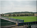
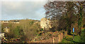
Hills and terraces viewed from the riverbank
Looking east across the rugby ground.
Image: © Robert Lamb
Taken: 31 Jul 2011
0.03 miles