IMAGES TAKEN NEAR TO
Raby Place, BATH, BA2 4EH
Introduction
This page details the photographs taken nearby to Raby Place, BA2 4EH by members of the Geograph project.
The Geograph project started in 2005 with the aim of publishing, organising and preserving representative images for every square kilometre of Great Britain, Ireland and the Isle of Man.

There are currently over 7.5m images from over14,400 individuals and you can help contribute to the project by visiting https://www.geograph.org.uk
Image Map
Images are licensed for reuse under creativecommons.org/licenses/by-sa/2.0
Notes
- Clicking on the map will re-center to the selected point.
- The higher the marker number, the further away the image location is from the centre of the postcode.
Image Listing (322 Images Found)
Images are licensed for reuse under creativecommons.org/licenses/by-sa/2.0
Image
Details
Distance
1
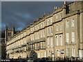
Raby Place
A row of typical Bath terracing at the bottom of Bathwick Hill.
Image: © Neil Owen
Taken: 28 Dec 2021
0.02 miles
2
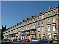
1-17 Raby Place, Bathwick Hill, Bath
Another exemplary example of the adeptness with which Bath's Georgian builders handled building on sloping ground. The continuous horizontal elements are ramped up between houses to avoid staccato breaks (Image]). Handsome houses, but of two rather than the more normal three bays. Built 1818-25 by John Pinch the Elder. The tented balconies are later C19th. Grade II* listed.
Image: © Stephen Richards
Taken: 25 May 2012
0.02 miles
3
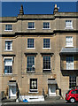
Detail of 3-4 Raby Place, Bathwick Hill, Bath
The parapet and cornice curve up to smooth the transition along sloping ground.
Full view: Image
Image: © Stephen Richards
Taken: 25 May 2012
0.02 miles
5
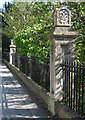
Gate piers, Bathwick Hill, Bath
At the perimeter of Raby Gardens. Decorated with anthemions. Together with the railings they date from the 1820s. Grade II listed.
Image: © Stephen Richards
Taken: 25 May 2012
0.03 miles
6
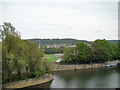
Hills and terraces viewed from N Parade #2
Looking east across the rugby pitch and the River Avon.
Image: © Robert Lamb
Taken: 31 Jul 2011
0.04 miles
7
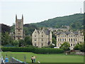
View of St Mary's Church from the riverbank
Looking east across the rugby pitch.
Image: © Robert Lamb
Taken: 31 Jul 2011
0.04 miles
8
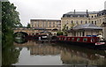
Kennet & Avon Canal, Bathwick
Looking south to Sydney Wharf Bridge Image
Image: © Pierre Terre
Taken: 19 May 2006
0.05 miles
9

St Mary's boltmark
A nineteenth century benchmark on the side of St Mary's church. See http://www.bench-marks.org.uk/bm32173 for the entry in the Benchmark Database and Image] for a wider view.
Image: © Neil Owen
Taken: 18 Jul 2011
0.06 miles
10

The side of St Mary's
The smaller side entrance to the church possesses a benchmark - see Image
Image: © Neil Owen
Taken: 18 Jul 2011
0.06 miles