IMAGES TAKEN NEAR TO
Upper Bloomfield Road, BATH, BA2 2SB
Introduction
This page details the photographs taken nearby to Upper Bloomfield Road, BA2 2SB by members of the Geograph project.
The Geograph project started in 2005 with the aim of publishing, organising and preserving representative images for every square kilometre of Great Britain, Ireland and the Isle of Man.

There are currently over 7.5m images from over14,400 individuals and you can help contribute to the project by visiting https://www.geograph.org.uk
Image Map
Images are licensed for reuse under creativecommons.org/licenses/by-sa/2.0
Notes
- Clicking on the map will re-center to the selected point.
- The higher the marker number, the further away the image location is from the centre of the postcode.
Image Listing (22 Images Found)
Images are licensed for reuse under creativecommons.org/licenses/by-sa/2.0
Image
Details
Distance
1
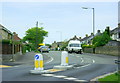
2008 : Upper Bloomfield Road, Bath
At the junction with Old Fosse Road.
A fairly modern housing development.
Image: © Maurice Pullin
Taken: 10 May 2008
0.03 miles

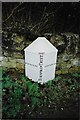
3

Old Boundary Marker on the A367 Roman Road
Parish Boundary Marker on the southwest side of the A367 Roman Road southwest of the junction with Combe Hay Road. Immediately to the northeast of SO_BARA03bpb. Combe Hay parish. Inscribed P / L AND W / 1894 and on the former boundary of Lyncombe with Widcombe parish. Grade II Listed details https://historicengland.org.uk/listing/the-list/list-entry/1320808. See also https://www.geograph.org.uk/photo/5655340.
Milestone Society National ID: SO_WID07pb
Image: © Roadside Relics
Taken: 2 Mar 2023
0.14 miles
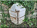
4

Old Boundary Marker on the A367 Roman Road
Turnpike Parish Boundary Marker on the southeast side of the A367 Roman Road southwest of the junction with Combe Hay Lane. Southwest of SO_WID07pb and northeast of SO_SSBA05cb. Formerly on the boundary of Widcombe and Combe Hay parishes but now on the boundary of an unparished area of Bath and North East Somerset and Combe Hay.
In raised lettering WIDCOMBE on the left face, COMBEHAY on the right face, (BATH) TURNPIKE TRUST perpendicularly on the front face with 1827 above this. Grade II Listed details https://historicengland.org.uk/listing/the-list/list-entry/1320808. See also https://www.geograph.org.uk/photo/5655340.
Milestone Society National ID: SO_BARA03bpb
Image: © Milestone Society
Taken: Unknown
0.14 miles
5
Old Boundary Marker on the A367 Roman Road
Turnpike Parish Boundary Marker on the southeast side of the A367 Roman Road southwest of the junction with Combe Hay Lane. Southwest of SO_WID07pb and northeast of SO_SSBA05cb. Formerly on the boundary of Widcombe and Combe Hay parishes but now on the boundary of an unparished area of Bath and North East Somerset and Combe Hay.
In raised lettering WIDCOMBE on the left face, COMBEHAY on the right face, (BATH) TURNPIKE TRUST perpendicularly on the front face with 1827 above this. Grade II Listed details https://historicengland.org.uk/listing/the-list/list-entry/1320808. See also https://www.geograph.org.uk/photo/5655340.
Milestone Society National ID: SO_BARA03bpb
Image: © J Dowding
Taken: 30 Dec 2007
0.14 miles
6
Old Boundary Marker on the A367 Roman Road
Turnpike Parish Boundary Marker on the southeast side of the A367 Roman Road southwest of the junction with Combe Hay Lane. Southwest of SO_WID07pb and northeast of SO_SSBA05cb. Formerly on the boundary of Widcombe and Combe Hay parishes but now on the boundary of an unparished area of Bath and North East Somerset and Combe Hay.
In raised lettering WIDCOMBE on the left face, COMBEHAY on the right face, (BATH) TURNPIKE TRUST perpendicularly on the front face with 1827 above this. Grade II Listed details https://historicengland.org.uk/listing/the-list/list-entry/1320808. See also https://www.geograph.org.uk/photo/5655340 and https://www.geograph.org.uk/photo/6043792.
Milestone Society National ID: SO_BARA03bpb
Image: © A Barrance
Taken: 1 Jun 2023
0.14 miles
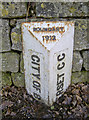
7

Old Boundary Marker on Roman Road
County Boundary Marker on the southwest side of the A367 Roman Road southwest of the junction with Combe Hay Road. Southwest of SO_BARA03bpb. On the former boundary of Combe Hay parish, Somerset county and the City of Bath. In raised lettering CITY OF BATH and SOMERSET C C vertically on adjacent faces and BOUNDARY / 1912 on its sloping top face. Grade II Listed details https://historicengland.org.uk/listing/the-list/list-entry/1320808. See also https://www.geograph.org.uk/photo/5655340.
Milestone Society National ID: SO_SSBA05cb
Image: © J Dowding
Taken: 30 Dec 2007
0.15 miles
8

2008 : Marker post of the Bath Turnpike Trust
The word "Bath" has been obscured by roadworks. The distances are approximately 2 miles to Widcombe and 1 1/2 miles to Combe Hay.
Image: © Maurice Pullin
Taken: 10 May 2008
0.15 miles
9

Where the Wansdyke and the Fosse Way meet
A crossroads of ancient carriageways here in the south of Bath: the Roman road and the ditch works converge around this point. Such a prominent landscape feature inevitably attracted the attention of the planners and administrators, as witnessed by the boundary markers of various ages. See Image] for a closer look at the white one.
Image: © Neil Owen
Taken: 17 Jan 2018
0.15 miles
10
Disappearing under the leaves
A boundary marker of over a hundred years stands a little lower on the road surface these days. It's interesting to note how the current boundary is now defined as Bath an North East Somerset - whereas Bath and Somerset were separate in the past. See Image] for a wider view of more markers.
Image: © Neil Owen
Taken: 17 Jan 2018
0.15 miles