IMAGES TAKEN NEAR TO
Englishcombe Lane, BATH, BA2 2ER
Introduction
This page details the photographs taken nearby to Englishcombe Lane, BA2 2ER by members of the Geograph project.
The Geograph project started in 2005 with the aim of publishing, organising and preserving representative images for every square kilometre of Great Britain, Ireland and the Isle of Man.

There are currently over 7.5m images from over14,400 individuals and you can help contribute to the project by visiting https://www.geograph.org.uk
Image Map
Images are licensed for reuse under creativecommons.org/licenses/by-sa/2.0
Notes
- Clicking on the map will re-center to the selected point.
- The higher the marker number, the further away the image location is from the centre of the postcode.
Image Listing (15 Images Found)
Images are licensed for reuse under creativecommons.org/licenses/by-sa/2.0
Image
Details
Distance
1
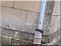
Ordnance Survey Cut Mark
This OS cut mark can be found on No237 Englishcombe Lane. It marks a point 101.214m above mean sea level.
Image: © Adrian Dust
Taken: 2 Dec 2022
0.01 miles
2
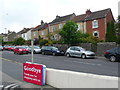
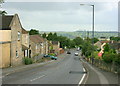
Houses on Englishcombe lane
A mixture of terraced and semi detached houses line this old route out of the city of Bath. The goodbye sign belongs to a Tesco Express store opposite the houses.
Image: © Nigel Mykura
Taken: 30 Sep 2012
0.04 miles
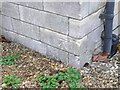
3

Ordnance Survey Cut Mark
This OS cut mark can be found on the wall SW side of Englishcombe Lane. It marks a point 90.936m above mean sea level.
Image: © Adrian Dust
Taken: 2 Dec 2022
0.08 miles
4
Ordnance Survey Cut Mark
This OS cut mark can be found on No17 Round Hill Grove. It marks a point 116.348m above mean sea level.
Image: © Adrian Dust
Taken: 2 Dec 2022
0.14 miles
5

Ordnance Survey Cut Mark
This OS cut mark can be found on No24 Mount Road. It marks a point 117.112m above mean sea level.
Image: © Adrian Dust
Taken: 2 Dec 2022
0.15 miles
6
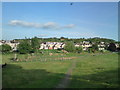
Southdown playing fields, Bath
Looking Southeast. The path is a public footpath as shown on the OS map, leading to Englishcombe Lane. The path on the left leads to Coronation Avenue.
Image: © Graham D
Taken: 20 May 2010
0.15 miles
7

Sunset at the top of Englishcombe Lane, Bath
Image: © Dave Atkinson
Taken: 8 Feb 2006
0.15 miles
8
2008 : Rush Hill, Bath
Near the bottom of Rush Hill. At the next crossroads it becomes Whiteway Road which continues to the A4 at Newton St.Loe.
Directly ahead on the skyline we have, left to right, Winsbury Hill and Stantonbury Hill Image which are near Stanton Prior.
Image: © Maurice Pullin
Taken: 10 Jul 2008
0.17 miles
9

Houses on Rush Hill
Although it's not a hill along this stretch, approaching the junction with Padleigh Hill and Englishcombe Lane.
Image: © Derek Harper
Taken: 16 Feb 2016
0.17 miles
